Glacier National Park Map and Entrances Explained
Glacier National Park Map
Click the image below to view map of Glacier National Park in full size.
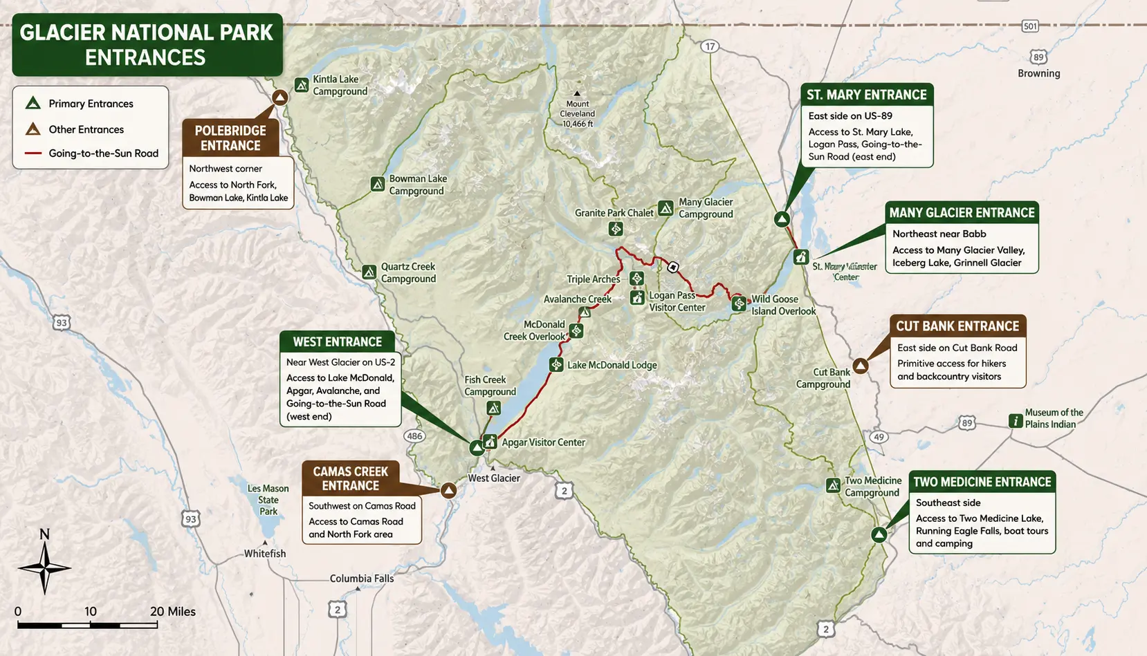
Glacier National Park has seven entrances, but four are the primary gateways most visitors use. Which entrance is best depends on the area you want to explore.
| Entrance | Location | Best For | Connects to Going-to-the-Sun Road? |
|---|---|---|---|
| West Entrance | West Glacier, Montana | Lake McDonald, Apgar Visitor Center, most first-time visitors | ✅ Yes |
| St. Mary Entrance | East side (US-89) | Logan Pass, St. Mary Lake, east-side hikes | ✅ Yes |
| Many Glacier Entrance | Northeast (near Babb) | Iceberg Lake, Grinnell Glacier, wildlife | ❌ No |
| Two Medicine Entrance | Southeast | Quieter hiking, lakes, camping | ❌ No |
| Polebridge Entrance | Northwest | North Fork, Bowman Lake, remote scenery | ❌ No |
| Camas Creek Entrance | Southwest | Camas Road, less crowded access | Limited (via Camas Road) |
| Cut Bank Entrance | East side | Primitive backcountry hiking | ❌ No |
1. West Entrance
- The most popular entrance.
- About 33 miles (53 km) from Kalispell and 30 miles (48 km) from Glacier Park International Airport.
- Provides access to:
- Apgar Visitor Center
- Lake McDonald
- Going-to-the-Sun Road
- Avalanche area
2. St. Mary Entrance
- Main entrance on the east side of the park.
- Ideal if you’re driving from Browning or Great Falls.
- Closest to:
- St. Mary Visitor Center
- Wild Goose Island
- Logan Pass (via Going-to-the-Sun Road)
3. Many Glacier Entrance
- Famous for spectacular hiking and wildlife.
- Popular trails include:
- Grinnell Glacier
- Iceberg Lake
- Ptarmigan Tunnel
- The road ends in the Many Glacier valley and does not connect to the rest of the park.
4. Two Medicine Entrance
- A quieter alternative with fewer crowds.
- Great for:
- Running Eagle Falls
- Two Medicine Lake
- Scenic boat tours
- Camping
5. Polebridge Entrance
- Accesses the remote North Fork area.
- Best for:
- Bowman Lake
- Kintla Lake
- Polebridge Mercantile
- Much of the road is unpaved.
6. Camas Creek Entrance
- Located along Camas Road.
- Connects the west side with the North Fork area.
- Usually less congested than the West Entrance.
7. Cut Bank Entrance
- A primitive entrance on the east side.
- No visitor services.
- Mainly used by experienced hikers and backpackers.
Which entrance should you choose?
- First-time visitors: West Entrance
- Driving the full Going-to-the-Sun Road: West Entrance or St. Mary Entrance
- Best hiking: Many Glacier Entrance
- Avoiding crowds: Two Medicine or Polebridge
- Wildlife photography: Many Glacier
Where Is Glacier National Park Located?
Glacier National Park is located in northwestern Montana, United States, along the border with Canada. The park covers more than 1 million acres (over 4,000 square kilometers) of rugged mountains, alpine lakes, forests, and glaciers.
The park shares an international border with Canada’s Waterton Lakes National Park. Together, the two parks form the Waterton-Glacier International Peace Park, the world’s first international peace park, established in 1932.
Glacier National Park Location
- State: Montana
- Region: Northwestern Montana
- Nearest international border: Alberta, Canada
- Coordinates: Approximately 48.7° N, 113.8° W
Nearby Cities
Several towns provide convenient access to Glacier National Park:
| City | Distance to West Entrance | Drive Time |
|---|---|---|
| West Glacier, MT | At the entrance | 0 minutes |
| Columbia Falls, MT | 17 miles (27 km) | 25 minutes |
| Whitefish, MT | 27 miles (43 km) | 40 minutes |
| Kalispell, MT | 33 miles (53 km) | 45 minutes |
| Missoula, MT | 150 miles (241 km) | 2.5–3 hours |
| Great Falls, MT | 140 miles (225 km) | About 3 hours (to St. Mary Entrance) |
Nearest Airport
The closest commercial airport is Glacier Park International Airport (FCA), located about 30 miles (48 km) southwest of the park’s West Entrance. The drive typically takes around 40 minutes.
Getting There
Visitors can reach Glacier National Park by:
- Car: Via U.S. Highway 2 (West Entrance), U.S. Highway 89 (St. Mary Entrance), and other regional roads.
- Train: Amtrak’s Empire Builder stops at West Glacier, Essex, and East Glacier Park, making rail travel a convenient option.
- Air: Fly into Glacier Park International Airport and rent a car or use seasonal shuttle services.
The National Park Service recommends choosing your entrance based on the specific region you plan to visit, since several park areas are dead-end valleys rather than interconnected roads.