Canyonlands National Park Map Guide: Trails, Districts, Scenic Drives & PDF Maps
Canyonlands National Park at a Glance
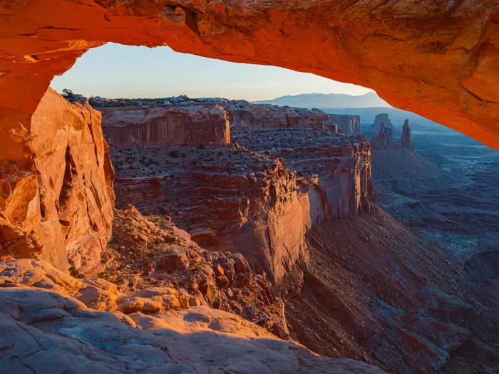
Located in southeastern Utah near Moab, Canyonlands protects a spectacular landscape carved over millions of years by the Colorado and Green Rivers.
The park consists of four distinct areas:
- Island in the Sky
- The Needles
- The Maze
- The Colorado and Green Rivers
Unlike many national parks, you cannot drive directly between the districts inside the park. Traveling between Island in the Sky and The Needles requires returning to public highways, and the drive typically takes about 2½–3 hours.
Understanding this layout is the first step to planning a successful visit.
Canyonlands National Park Overview Map
Click the image below to view map of Canyonlands National Park in full size.
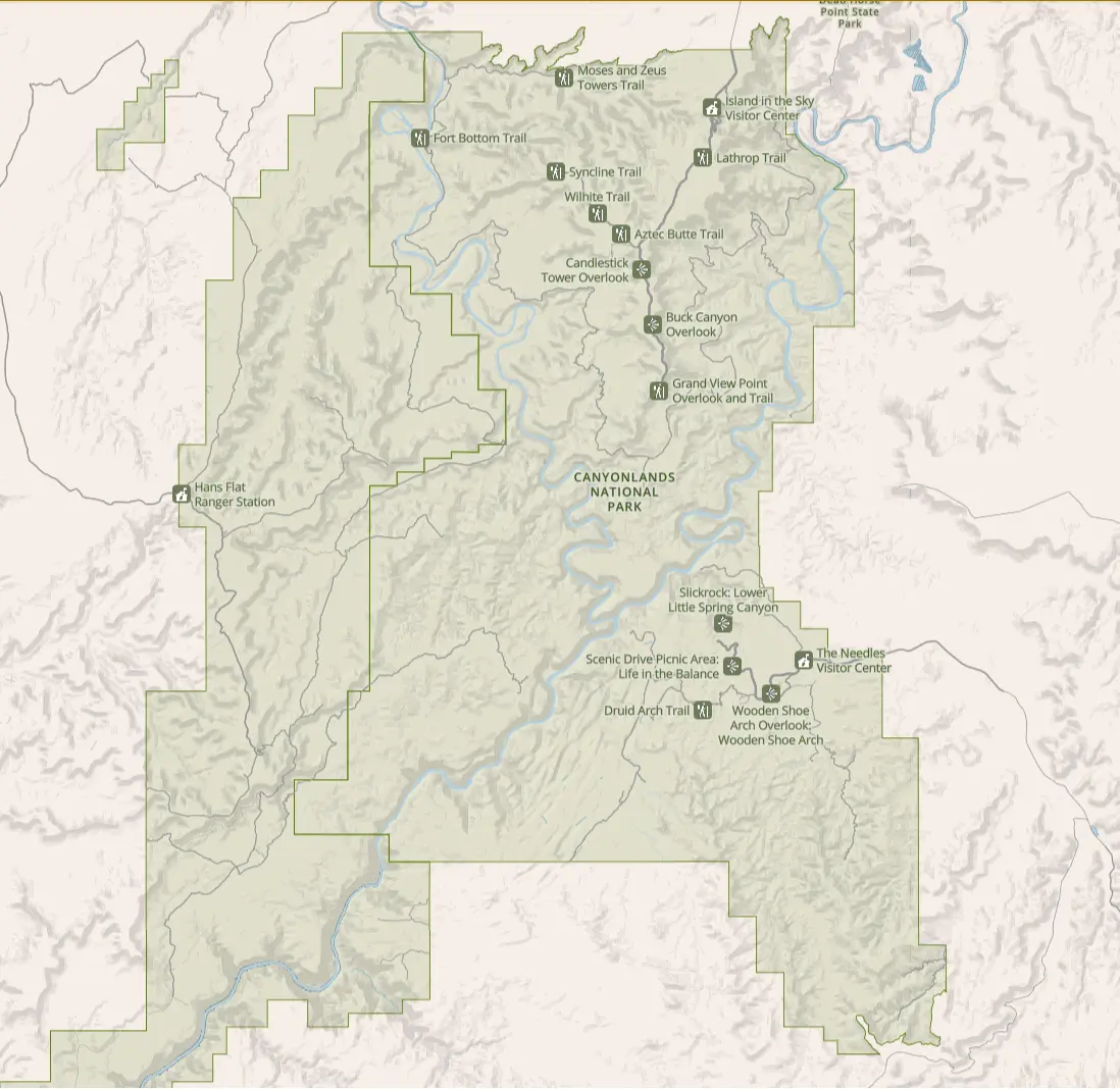
If you want to download Canyonlands National Park PDF file you can click here
Island in the Sky Map
Island in the Sky is the park’s most visited district. Sitting atop a massive mesa over 1,000 feet above the surrounding landscape, it offers incredible panoramic views with relatively easy access.
The district is about 35 miles southwest of Moab.
The main scenic drive stretches approximately 18 miles from the visitor center to Grand View Point.
Click the image below to view map of Island in the Sky in full size.
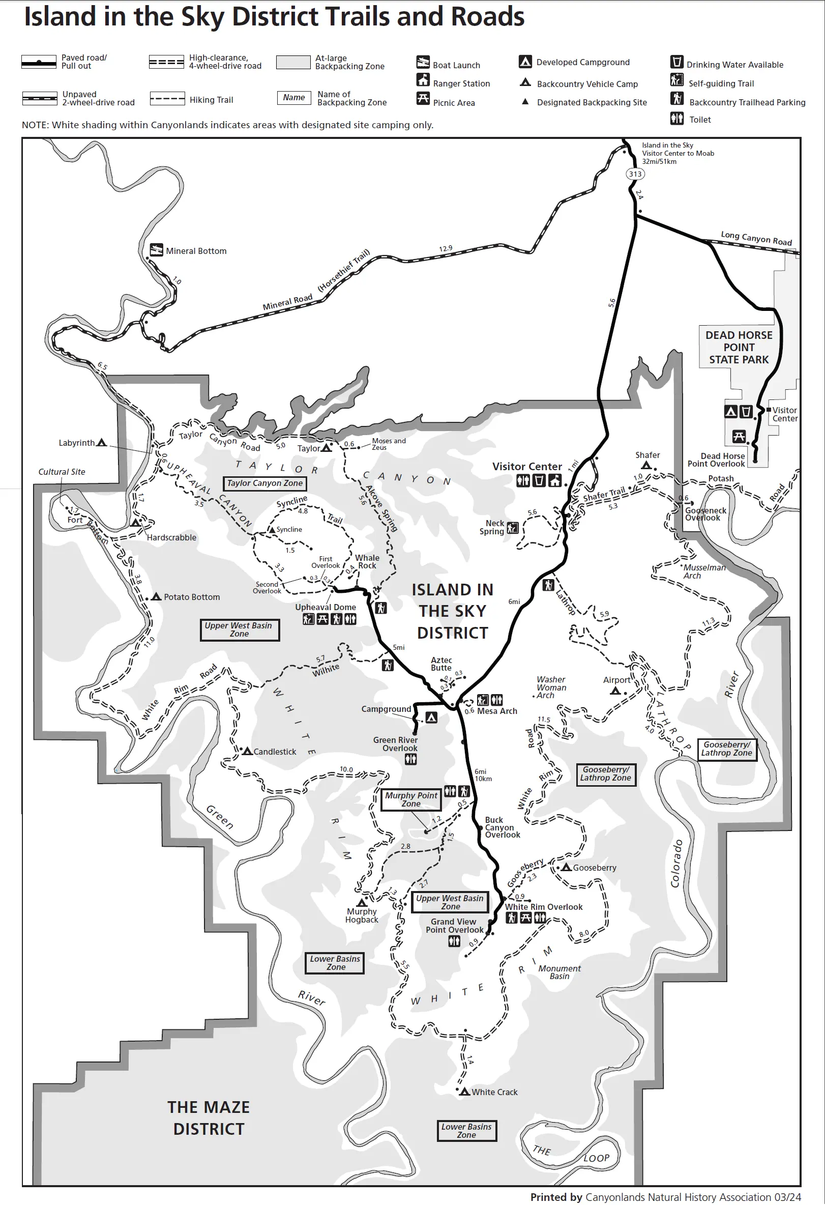
Popular stops include:
- Mesa Arch
- Shafer Canyon Viewpoint
- Buck Canyon Overlook
- Green River Overlook
- White Rim Overlook
- Grand View Point
- Upheaval Dome
The Island in the Sky map also marks:
- Trailheads
- Parking areas
- Picnic locations
- Restrooms
- Campgrounds
- Ranger stations
Since many hikes begin directly from parking areas, this is the most useful map for day visitors.
Island in the Sky Hiking Map
The hiking map provides greater detail than the overview map.
Popular trails include:
| Trail | Distance (Round Trip) | Difficulty |
|---|---|---|
| Mesa Arch | 0.7 mi | Easy |
| White Rim Overlook | 1.8 mi | Easy |
| Grand View Point | 1.8 mi | Easy |
| Upheaval Dome (1st Overlook) | 0.8 mi | Easy |
| Upheaval Dome (2nd Overlook) | 1.8 mi | Moderate |
| Murphy Point | 3.6 mi | Moderate |
| Syncline Loop | 8.5 mi | Difficult |
Trail maps indicate:
- Elevation changes
- Junctions
- Scenic viewpoints
- Trail distances
- Water availability (very limited)
The Needles Map
The Needles district lies south of Island in the Sky and features colorful sandstone spires, extensive hiking trails, and excellent backpacking opportunities.
Unlike Island in the Sky, many attractions here require longer hikes.
The map identifies:
- Needles Visitor Center
- Squaw Flat Campground
- Elephant Hill
- Chesler Park
- Joint Trail
- Big Spring Canyon
- Confluence Overlook
- Road network
Roads are paved until Elephant Hill, beyond which high-clearance 4WD vehicles are required.
Best Hikes in The Needles
Popular trails shown on the map include:
| Trail | Distance | Difficulty |
|---|---|---|
| Cave Spring | 0.6 mi | Easy |
| Slickrock Trail | 2.4 mi | Easy |
| Pothole Point | 0.6 mi | Easy |
| Chesler Park Loop | 10.8 mi | Moderate |
| Druid Arch | 10.8 mi | Moderate |
| Joint Trail | 11 mi | Moderate |
| Confluence Overlook | 11 mi | Moderate |
Trail maps become especially important because many routes intersect.
The Maze Map
The Maze is one of the most remote regions in the U.S. National Park System.
There are:
- No paved roads
- Very limited signage
- No services
- No fuel
- Extremely rough roads
Most visitors require:
- High-clearance 4WD vehicles
- GPS navigation
- Paper maps
- Extra food
- Water
- Camping permits
The Maze map identifies:
- Flint Trail
- Hans Flat Ranger Station
- Doll House
- Maze Overlook
- Land of Standing Rocks
- Teapot Rock
Travel here should only be attempted by experienced backcountry travelers.
White Rim Road Map
The White Rim Road is one of America’s most famous four-wheel-drive routes.
The loop is approximately 100 miles long and circles beneath Island in the Sky.
The map marks:
- Campsites
- Permitted camping zones
- Shafer Trail
- Mineral Bottom Road
- Murphy Hogback
- Hardscrabble Hill
- Airport Tower
- Musselman Arch
Because permits are required for overnight trips, many visitors use detailed White Rim Road maps when planning camping itineraries.
Colorado & Green Rivers Map
The rivers that carved Canyonlands are destinations themselves.
River maps identify:
- Launch ramps
- Rapids
- Campsites
- Confluences
- River mileage
- Hiking access
- Permit zones
Boaters typically use specialized river maps in addition to topographic maps.
Canyonlands Scenic Drive Map
If you’re spending only one day in the park, a scenic drive map is extremely helpful.
A typical route includes:
- Visitor Center
- Shafer Canyon Viewpoint
- Mesa Arch
- Green River Overlook
- Buck Canyon
- White Rim Overlook
- Grand View Point
- Upheaval Dome
This drive covers most of Island in the Sky’s iconic viewpoints while allowing time for several short hikes.
Backcountry & Topographic Maps
Many areas of Canyonlands have no cell service.
Visitors heading into remote areas should carry:
- USGS topographic maps
- National Geographic Trails Illustrated maps
- GPS devices
- Offline navigation apps
- Paper backup maps
Topographic maps show:
- Elevation contours
- Canyons
- Washes
- Backcountry roads
- Primitive campsites
They are strongly recommended for backpackers and off-road travelers.
Which Canyonlands Map Should You Use?
The best map depends on your plans.
| Activity | Recommended Map |
|---|---|
| First visit | Park overview map |
| One-day sightseeing | Island in the Sky map |
| Hiking | District trail maps |
| Backpacking | Topographic maps |
| White Rim Road | White Rim Road map |
| Off-roading | 4WD route map |
| River trips | River map |
| Camping | Campground map |
Tips for Using a Canyonlands National Park Map
Before entering the park:
- Download offline maps.
- Carry a printed park map.
- Check current road conditions.
- Fill your fuel tank before arriving.
- Bring more water than you think you’ll need.
- Do not rely solely on mobile navigation.
Travel times inside Canyonlands are often longer than expected because roads are winding, speed limits are low, and the districts are widely separated.
Frequently Asked Questions
Is Canyonlands National Park divided into separate areas?
Yes. Canyonlands has four districts: Island in the Sky, The Needles, The Maze, and the Colorado & Green Rivers.
Which district is best for first-time visitors?
Island in the Sky is the easiest to access and offers many of the park’s most famous viewpoints within a single scenic drive.
Can you drive between Island in the Sky and The Needles?
No. There is no internal road connecting the districts. You must return to public highways, making the drive between them approximately 2½–3 hours.
Is there cell service inside Canyonlands National Park?
Cell service is limited and unreliable in much of the park, especially outside Island in the Sky. Download offline maps before your visit.
Is the White Rim Road suitable for regular cars?
No. The White Rim Road requires a high-clearance four-wheel-drive vehicle, and overnight trips require permits.
Should I bring a paper map?
Yes. Paper maps remain one of the most reliable navigation tools, particularly in remote areas where GPS signals or mobile service may be unavailable.
Final Thoughts
A Canyonlands National Park map is more than a navigation aid—it’s the key to understanding one of the most expansive and rugged landscapes in the American Southwest. Whether you’re exploring the easily accessible overlooks of Island in the Sky, hiking among the sandstone formations of The Needles, tackling the legendary White Rim Road, or venturing into the remote Maze District, using the right map will help you travel safely, manage your time effectively, and discover the park’s most memorable scenery. Download an official PDF map before you arrive, keep a printed copy in your vehicle, and enjoy exploring Canyonlands with confidence.