Death Valley National Park Map: Your Complete Guide to Exploring America’s Largest National Park
Death Valley National Park is one of the most extraordinary landscapes in the United States. Covering more than 3.4 million acres across eastern California and western Nevada, it’s the largest national park in the contiguous U.S. Because of its enormous size, having a reliable Death Valley National Park map is essential for planning your trip.
Whether you’re visiting for a day or spending a week exploring the desert, this guide explains how to use the park map, highlights major roads and attractions, and helps you navigate safely.
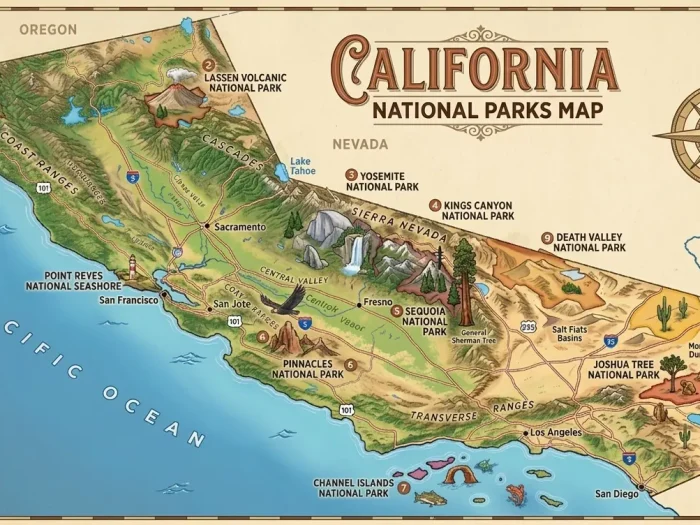
Death Valley National Park Map
Click the image below to view the full-size Death Valley National Park Map.
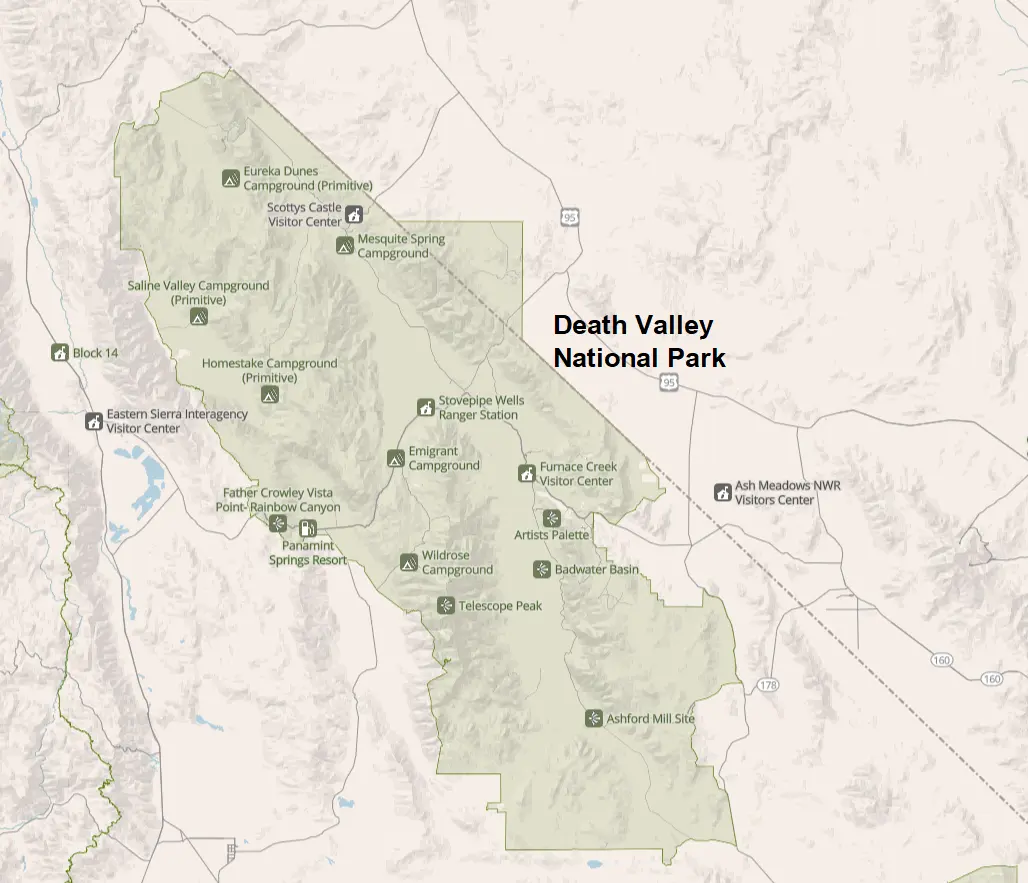
If you want to download Death Valley National Park map PDF file you click here
Death Valley National Park at a Glance
| Feature | Details |
|---|---|
| State | California & Nevada |
| Size | 3.4 million acres |
| Established | National Monument (1933), National Park (1994) |
| Highest Point | Telescope Peak (11,049 ft) |
| Lowest Point | Badwater Basin (-282 ft) |
| Main Visitor Center | Furnace Creek Visitor Center |
| Scenic Drive | CA-190 |
Where Is Death Valley National Park?
Death Valley National Park is located in eastern California, extending into western Nevada.
It lies approximately:
- 120 miles from Las Vegas
- 275 miles from Los Angeles
- 290 miles from Bakersfield
- 310 miles from San Diego
Because the park covers such a vast area, driving between attractions often takes longer than visitors expect.
Main Roads on the Map
CA-190
California Highway 190 is the primary east-west road through Death Valley.
It connects:
- Panamint Springs
- Stovepipe Wells
- Furnace Creek
- Death Valley Junction
Most visitors spend much of their trip driving along CA-190.
Badwater Road
This scenic road leads south from Furnace Creek toward:
- Badwater Basin
- Devil’s Golf Course
- Natural Bridge
- Artist Drive
Scotty’s Castle Road
Although Scotty’s Castle itself has experienced closures due to flood damage and restoration work, this road still provides access to portions of northern Death Valley when open.
Always check current road conditions before your visit.
Daylight Pass Road
This route connects:
- Beatty, Nevada
- Hell’s Gate
- Furnace Creek
It is one of the most popular eastern entrances.
Emigrant Canyon Road
This scenic drive provides access to:
- Wildrose Canyon
- Charcoal Kilns
- Mahogany Flat Campground
- Telescope Peak Trailhead
Death Valley National Park Entrances
Unlike many national parks, Death Valley has multiple entrance roads, and there are no entrance gates where visitors stop to pay. Entrance fees are paid online or at self-pay stations.
East Entrance (Las Vegas)
This is the most popular entrance for visitors arriving from Las Vegas.
Highlights include:
- Hell’s Gate
- Zabriskie Point
- Furnace Creek
Driving time from Las Vegas: About 2 hours
West Entrance
Travelers coming from:
- Lone Pine
- Sequoia National Park
- Bakersfield
typically enter via CA-190 through Panamint Springs.
South Entrance
The southern approach uses CA-178 near Shoshone.
This quieter route offers dramatic desert scenery.
North Entrance
Visitors coming from:
- Beatty
- Scotty’s Junction
- Big Pine
may enter from the northern roads depending on seasonal conditions.
Visitor Centers on the Map
Furnace Creek Visitor Center
This is the main information hub.
Facilities include:
- Park maps
- Exhibits
- Ranger programs
- Restrooms
- Water
- Gift shop
- Trip planning assistance
Stovepipe Wells Ranger Station
Located near the Mesquite Flat Sand Dunes, this station provides:
- Information
- Water
- Restrooms
Major Attractions on the Map
Badwater Basin
The park’s most famous destination.
Highlights:
- Lowest point in North America
- Salt flats
- Easy walking trail
Distance from Furnace Creek: 17 miles
Zabriskie Point
One of the best sunrise locations in Death Valley.
Known for:
- Golden badlands
- Panoramic viewpoints
- Short paved walk
Mesquite Flat Sand Dunes
Perfect for:
- Photography
- Sunrise
- Sunset
- Sand dune exploration
Located near Stovepipe Wells.
Artist Drive
A scenic one-way road featuring colorful volcanic hills.
Includes: Artist Palette overlook
Drive length: 9 miles
Dante’s View
Elevation:
5,475 feet
Offers spectacular views overlooking:
- Badwater Basin
- Panamint Range
- Telescope Peak
Devil’s Golf Course
An enormous field of jagged salt formations.
Easy roadside stop.
Natural Bridge
A short hike leads to a beautiful natural rock bridge hidden within a canyon.
Golden Canyon
Popular hiking destination connecting to:
- Red Cathedral
- Zabriskie Point
Telescope Peak
The highest mountain in the park.
Excellent summer hiking destination with incredible panoramic views.
Scenic Drives
One of the best ways to explore Death Valley is by car.
Popular scenic routes include:
| Drive | Distance |
|---|---|
| Artist Drive | 9 miles |
| Badwater Road | 45 miles round trip |
| Emigrant Canyon Road | 28 miles |
| Titus Canyon Road* | 27 miles |
| Twenty Mule Team Canyon | 2.7 miles |
*Seasonally open and suitable only for high-clearance vehicles traveling one way from east to west.
Campgrounds on the Map
Major campgrounds include:
- Furnace Creek Campground
- Sunset Campground
- Texas Springs Campground
- Stovepipe Wells Campground
- Mesquite Spring Campground
- Wildrose Campground
- Thorndike Campground
- Mahogany Flat Campground
Some campgrounds require reservations during peak season.
Gas Stations
Fuel is available at:
- Furnace Creek
- Stovepipe Wells
- Panamint Springs
Gas stations are far apart, so always fill your tank before exploring remote areas.
Cell Service and GPS
Most of Death Valley has little to no cell service.
Before entering the park:
- Download offline maps.
- Save your lodging reservation.
- Download hiking routes.
- Carry a paper park map.
GPS navigation can occasionally route drivers onto unmaintained roads, so compare your route with the official park map.
Best Areas for First-Time Visitors
If you have one day, focus on:
- Zabriskie Point
- Badwater Basin
- Devil’s Golf Course
- Artist Drive
- Mesquite Flat Sand Dunes
- Dante’s View (if time allows)
These attractions are clustered around Furnace Creek, minimizing driving time.
Tips for Using the Death Valley National Park Map
- Fill up your gas tank before entering the park.
- Carry plenty of drinking water.
- Download offline navigation maps.
- Check road conditions before your trip, especially after storms.
- Expect long driving distances between attractions.
- Keep an eye on elevation changes, which can affect temperatures.
- Never rely solely on GPS for navigation.
Frequently Asked Questions
Where can I get a Death Valley National Park map?
You can pick up a free printed map at the Furnace Creek Visitor Center, entrance information stations, or download a digital version from the National Park Service before your visit.
Is Death Valley difficult to navigate?
Not if you stay on the main paved roads. However, the park is enormous, and many attractions are separated by long drives. A map helps you plan an efficient route and avoid unnecessary backtracking.
What is the best entrance to Death Valley National Park?
The east entrance via Daylight Pass Road is the most popular for visitors coming from Las Vegas, while CA-190 from the west is convenient for travelers from California.
Can I drive through the entire park in one day?
You can see many of the park’s iconic sights in a day, but exploring the entire park—including remote areas like Racetrack Playa, Eureka Dunes, or the northern backcountry—requires several days.
Is Google Maps reliable in Death Valley?
Google Maps works reasonably well on the main roads if you’ve downloaded offline maps in advance. Because cellular coverage is very limited, carrying an official park map is strongly recommended.
Final Thoughts
A Death Valley National Park map is one of the most valuable tools you can bring when visiting this vast desert landscape. With multiple entrances, long distances between attractions, and limited services in remote areas, careful planning will help you make the most of your trip. Whether you’re watching the sunrise at Zabriskie Point, walking across the salt flats of Badwater Basin, or taking in the sweeping views from Dante’s View, a good map ensures you can explore safely and efficiently while experiencing the remarkable diversity of North America’s hottest national park.