Denali National Park Map and Entrances Explained
Denali National Park at a Glance
| Feature | Details |
|---|---|
| Location | Interior Alaska, USA |
| Size | 6.1 million acres (2.47 million hectares) |
| Established | February 26, 1917 |
| Highest Peak | Denali (20,310 ft / 6,190 m) |
| Main Road | Denali Park Road |
| Visitor Center | Denali Visitor Center |
| Nearest Town | Healy, Alaska |
| Best Time to Visit | Late May through mid-September |
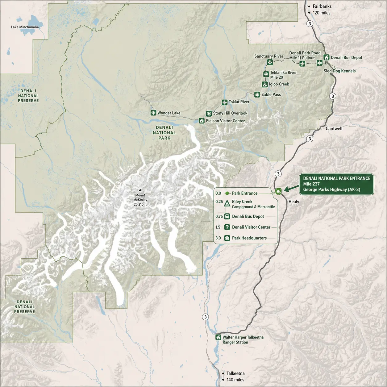
Denali National Park Map
Click the image below to view map of Denali National Park in full size.
Where Is Denali National Park?
Denali National Park is located in south-central Alaska, roughly halfway between Anchorage and Fairbanks.
Approximate driving distances:
- Anchorage: 240 miles (386 km) – about 4.5–5 hours
- Fairbanks: 125 miles (201 km) – about 2.5 hours
- Talkeetna: 150 miles (241 km)
The park is easily reached via the George Parks Highway (AK-3).
Denali National Park Entrances
Unlike many U.S. national parks, Denali National Park and Preserve has only one official road entrance.
Main Entrance
- Location: Mile 237 of the George Parks Highway (Alaska Highway 3)
- GPS coordinates: 63.728443, -148.886572
- Distance from Anchorage: About 240 miles (386 km) (approximately 5 hours by car)
- Distance from Fairbanks: About 120 miles (193 km) (approximately 2 hours by car)
What You’ll Find at the Entrance
After entering the park, you’ll reach the main visitor facilities within the first couple of miles:
| Mile | Facility |
|---|---|
| 0.0 | Park entrance |
| 0.25 | Riley Creek Campground & Mercantile |
| 0.75 | Denali Bus Depot |
| 1.5 | Denali Visitor Center |
| 3.0 | Park Headquarters area |
These facilities include parking, restrooms, ranger information, campgrounds, bus departures, and hiking trailheads.
Can You Enter from Another Side?
No. Denali has only one road entrance. Although the park covers over 6 million acres, there are no southern, eastern, or western vehicle entrances. The 92-mile Denali Park Road begins at the single entrance and extends west into the park.
Driving Access
- Private vehicles may normally drive only the first section of the park road (access limits can vary by season and current road conditions).
- To travel farther into the park, visitors typically use the park’s shuttle or tour buses.
- The road beyond the accessible section has experienced long-term closures due to the Pretty Rocks landslide, affecting how far buses can travel.
Quick facts
- ✅ Number of vehicle entrances: 1
- 🚗 Entrance highway: George Parks Highway (AK-3)
- 📍 Mile marker: 237
- 🏕️ Closest town: Healy, Alaska (about 12 miles north)
Main Areas on the Denali National Park Map
1. Park Entrance Area (Mile 0)
Most visitors begin here.
Facilities include:
- Entrance station
- Alaska Railroad depot
- Hotels and lodges nearby
- Restaurants
- Shuttle bus departures
- Parking areas
This is where your Denali adventure officially begins.
2. Denali Visitor Center (Mile 1.5)
The visitor center is the best place to start your trip.
You’ll find:
- Interactive exhibits
- Ranger programs
- Trail information
- Wildlife updates
- Backcountry permits
- Restrooms
- Gift shop
- Junior Ranger activities
Nearby trails include:
- Horseshoe Lake Trail
- McKinley Station Trail
- Taiga Trail
- Rock Creek Trail
3. Savage River Area (Mile 15)
Savage River marks the end of the road for most private vehicles.
Popular activities:
- Savage River Loop Trail
- Savage Alpine Trail
- River views
- Wildlife watching
- Photography
Many visitors spend half a day exploring this area.
4. Eielson Visitor Center (Around Mile 66)
One of the most scenic stops inside the park.
Highlights include:
- Incredible views of Denali on clear days
- Alpine hiking
- Exhibits
- Ranger talks
- Restrooms
This is often considered one of the best viewpoints in the park.
5. Wonder Lake (Around Mile 85)
Wonder Lake is famous for:
- Mirror-like reflections of Denali
- Canoeing
- Camping
- Moose sightings
- Photography
On calm mornings, this is one of Alaska’s most photographed locations.
6. Kantishna (End of Park Road)
Located near Mile 92.
This remote area offers:
- Historic mining sites
- Wilderness lodges
- Guided hikes
- Fishing
- Flightseeing tours
Only shuttle buses, tour buses, and authorized vehicles reach Kantishna.
Denali Park Road Map
The park road is divided into several major sections.
| Mile | Destination | Accessible by Private Vehicle |
|---|---|---|
| 0 | Park Entrance | Yes |
| 1.5 | Visitor Center | Yes |
| 3 | Headquarters | Yes |
| 9 | Primrose Ridge | Yes |
| 15 | Savage River | Yes |
| 30+ | Polychrome Area | Shuttle or tour bus |
| 43 | Toklat River | Shuttle or tour bus |
| 66 | Eielson Visitor Center | Shuttle or tour bus |
| 85 | Wonder Lake | Shuttle or tour bus |
| 92 | Kantishna | Shuttle or tour bus |
Best Hiking Areas on the Map
Denali is famous for both maintained trails and cross-country hiking.
Popular marked trails include:
Horseshoe Lake Trail
- Easy
- 2 miles round trip
- Beaver ponds
- Lake views
Savage River Loop
- Easy
- 2 miles
- River scenery
- Great for families
Savage Alpine Trail
- Moderate
- Around 4 miles one way
- Ridge hiking
- Mountain views
Triple Lakes Trail
- Challenging
- Nearly 10 miles
- Lakes
- Forest
- Wildlife
Mount Healy Overlook Trail
- Moderate
- Excellent panoramic views
- Near the visitor center
Wildlife Viewing Areas
The map can also help visitors identify prime wildlife viewing locations.
Animals commonly seen include:
- Grizzly bears
- Black bears
- Moose
- Caribou
- Dall sheep
- Wolves (rare)
- Red foxes
- Golden eagles
Wildlife sightings improve farther along the park road.
Morning and evening are generally the best times.
Campgrounds on the Map
Major campgrounds include:
| Campground | Mile | Notes |
|---|---|---|
| Riley Creek | 0.3 | Open to RVs and tents |
| Savage River | 13 | Scenic riverside camping |
| Sanctuary River | 23 | Tent camping |
| Teklanika River | 29 | Multi-night stays |
| Igloo Creek | 35 | Small campground |
| Wonder Lake | 85 | Beautiful mountain views |
Reservations are recommended during summer.
Scenic Viewpoints
Favorite photo locations include:
- Denali View South
- Horseshoe Lake
- Savage River
- Polychrome Pass
- Toklat River
- Eielson Visitor Center
- Wonder Lake
- Reflection Pond
Remember that Denali (the mountain) is often hidden by clouds, so flexibility improves your chances of seeing it.
Transportation Inside the Park
The map also helps visitors understand transportation options.
Private Vehicle
Allowed only on the initial section of Denali Park Road, subject to current seasonal road access.
Shuttle Bus
Ideal for:
- Independent travelers
- Wildlife viewing
- Hiking access
Narrated Bus Tours
Perfect for:
- First-time visitors
- Learning park history
- Photography
Hiking
Many areas encourage off-trail hiking, provided visitors follow Leave No Trace principles.
Downloading a Denali National Park Map
Before your trip, it’s a good idea to download an official park map because cell service is limited inside the park.
The official map typically includes:
- Park Road mile markers
- Shuttle bus stops
- Hiking trails
- Campgrounds
- Visitor centers
- Picnic areas
- Restrooms
- Scenic viewpoints
- Wildlife safety information
You can also pick up a free printed map at the visitor center upon arrival.
Tips for Using the Park Map
- Download an offline map before entering the park.
- Note mile markers—they’re the primary way locations are referenced in Denali.
- Plan shuttle or tour bus stops in advance, as you cannot simply drive to most destinations.
- Carry a paper map as a backup since mobile coverage is limited.
- Allow extra travel time; buses make frequent stops for wildlife viewing.
Frequently Asked Questions
Can you drive the entire Denali Park Road?
No. Most private vehicles are limited to the first portion of Denali Park Road. Access beyond that is generally by park shuttle or tour bus, depending on current road conditions and seasonal operations.
Is there only one entrance to Denali National Park?
Yes. The park has one main public entrance located on the George Parks Highway (AK-3).
Where should first-time visitors start?
Begin at the Denali Visitor Center to pick up maps, check trail and wildlife information, and learn about shuttle or tour bus options.
Is Google Maps enough for visiting Denali?
Google Maps is helpful for reaching the park, but an official park map provides detailed information on shuttle routes, trails, facilities, and mile markers that standard navigation apps may not include.
What is the best area for wildlife viewing?
The sections of Denali Park Road beyond Savage River—especially around Toklat, Eielson, and Wonder Lake—are among the best areas for spotting bears, moose, caribou, Dall sheep, and other wildlife.
Final Thoughts
A Denali National Park map is essential for planning a successful visit to one of America’s most spectacular wilderness areas. Because access beyond the first section of Denali Park Road relies on buses and careful trip planning, understanding the map ahead of time can help you maximize your time, choose the best hiking trails, locate scenic viewpoints, and improve your chances of unforgettable wildlife encounters. Whether you’re visiting for a single day or spending several nights exploring Alaska’s backcountry, a good map will help you navigate Denali with confidence.