Channel Islands National Park Map: Complete Guide to Islands, Trails, Ferry Routes & Visitor Areas
A Channel Islands National Park map is one of the most valuable planning tools for visiting America’s most remote national park. Unlike most U.S. national parks, Channel Islands has no roads connecting its five islands, and every visit requires transportation by boat or plane. Understanding the park map before your trip will help you choose the right island, locate hiking trails, campgrounds, ferry docks, and visitor facilities.
Channel Islands National Park Map Overview
Channel Islands National Park is located off the coast of Southern California and protects five of the eight Channel Islands:
- Anacapa Island
- Santa Cruz Island
- Santa Rosa Island
- San Miguel Island
- Santa Barbara Island
The park also includes the surrounding ocean waters extending one nautical mile from each island, while the surrounding waters are protected by the Channel Islands National Marine Sanctuary.
Unlike traditional national parks, there are:
- No park entrance roads
- No scenic drives
- No shuttle buses
- No bridges between islands
Every island must be reached separately.
Channel Islands National Park Map
Click the image below to view map of Channel Islands National Park in full size.
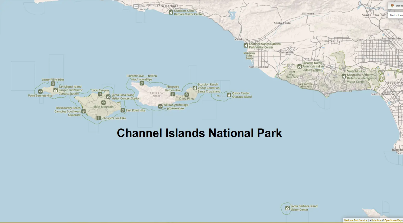
If you want to download Channel Islands National Park map PDF file you click here
What You’ll Find on a Channel Islands National Park Map
An official park map typically includes:
- Mainland visitor centers
- Ferry departure harbors
- All five islands
- Hiking trails
- Campgrounds
- Picnic areas
- Restrooms
- Ranger stations
- Sea cave and kayaking areas
- Marine protected zones
- Landing docks
- Elevation and topography
The official National Park Service map also shows island distances, transportation routes, and important safety information.
Mainland Access Points
Before reaching the islands, visitors begin on California’s mainland.
Robert J. Lagomarsino Visitor Center
Located in Ventura Harbor, this is the park’s primary visitor center.
Features include:
- Trip planning information
- Exhibits
- Junior Ranger activities
- Park bookstore
- Maps
- Restrooms
Most visitors stop here before boarding their ferry.
Ventura Harbor
Ventura Harbor serves as the primary departure point for ferry service to:
- Anacapa Island
- Santa Cruz Island
- Santa Rosa Island
- San Miguel Island
Channel Islands Harbor (Oxnard)
Some ferry departures to:
- Anacapa Island
- Santa Cruz Island
also leave from Channel Islands Harbor.
Your map usually marks both ferry terminals clearly.
Map of the Five Islands
1. Anacapa Island
Anacapa is the closest island to the mainland and one of the easiest for first-time visitors.
Map highlights include:
- Landing Cove
- Inspiration Point
- Historic Lighthouse
- Cathedral Cove
- Visitor Center
- Campground
- Short hiking trails
Most trails are relatively easy and can be completed in a day.
2. Santa Cruz Island
Santa Cruz is the largest and most visited island.
Maps usually divide it into two visitor areas:
Scorpion Anchorage
Popular for:
- Day hiking
- Kayaking
- Camping
- Wildlife viewing
Key map locations:
- Cavern Point Loop
- Potato Harbor
- Scorpion Campground
- Cavern Point Trail
- Sea caves
Prisoners Harbor
Less crowded than Scorpion.
Popular trails include:
- Pelican Bay
- Del Norte Campground
- Navy Road
- Montañon Ridge
3. Santa Rosa Island
Santa Rosa offers wide beaches and longer hikes.
Important map locations:
- Water Canyon Campground
- Bechers Bay
- Torrey Pines
- Lobo Canyon
- Cherry Canyon
- Black Mountain Road
Distances here are much greater than on Anacapa.
4. San Miguel Island
San Miguel is the westernmost island and one of the wildest.
Maps show:
- Cuyler Harbor
- Nidever Canyon
- Ranger Station
- Point Bennett
- Seal viewing areas
Many areas require ranger guidance due to weather and wildlife protections.
5. Santa Barbara Island
The smallest island in the park features dramatic cliffs and seabird colonies.
Map highlights include:
- Landing Cove
- Campground
- Arch Point
- Elephant Seal Overlook
- Signal Peak Trail
The island can usually be explored in a single day.
Hiking Trails on the Map
The official map labels the primary hiking trails on each island.
Popular trails include:
| Island | Popular Trail | Distance |
|---|---|---|
| Anacapa | Inspiration Point | Short |
| Anacapa | Cathedral Cove | Short |
| Santa Cruz | Cavern Point Loop | Easy |
| Santa Cruz | Potato Harbor Trail | Moderate |
| Santa Rosa | Lobo Canyon | Moderate |
| Santa Rosa | Black Mountain | Strenuous |
| San Miguel | Point Bennett | Long |
| Santa Barbara | Signal Peak | Moderate |
Trail distances vary considerably depending on the island.
Campgrounds Shown on the Map
Each island has primitive camping.
Campgrounds include:
- Anacapa Campground
- Scorpion Campground
- Del Norte Campground
- Water Canyon Campground
- Cuyler Harbor Campground
- Santa Barbara Campground
Maps indicate:
- Tent sites
- Restrooms
- Water availability
- Food storage
- Picnic tables
Most campgrounds require advance reservations.
Ferry Routes
One of the most useful features is the ferry route map.
The map illustrates:
- Ventura → Anacapa
- Ventura → Santa Cruz
- Ventura → Santa Rosa
- Ventura → San Miguel
- Oxnard → Anacapa
- Oxnard → Santa Cruz
Travel times generally range from about 1 to 4 hours, depending on the destination and sea conditions.
Marine Protected Areas
Many maps also display marine protected areas surrounding the islands.
These zones help conserve:
- Kelp forests
- Sea lions
- Dolphins
- Whales
- Seabirds
- Fish populations
- Giant sea bass
Certain fishing activities are restricted within these protected waters.
Wildlife Viewing Locations
Maps often identify the best places to observe wildlife.
Popular locations include:
Anacapa Island
- Western gull colonies
- California sea lions
Santa Cruz Island
- Island fox
- Bald eagles
- Sea caves
Santa Rosa Island
- Elk
- Rare Torrey pine groves
San Miguel Island
- Elephant seals
- Fur seals
- Sea lions
Santa Barbara Island
- Brown pelicans
- Cormorants
- Western gulls
How to Use the Map When Planning Your Trip
A map can help you decide:
- Which island best matches your interests
- Hiking distances
- Campground locations
- Ferry arrival points
- Available facilities
- Water sources
- Restroom locations
- Emergency contact points
- Scenic overlooks
- Kayaking access
Because transportation between islands is limited, reviewing the map before your visit can save time and help you choose the right destination.
Download the Official Channel Islands National Park Map
The National Park Service provides several free downloadable maps, including:
- Complete park map
- Individual island hiking maps
- Sea kayaking maps
- Visitor center maps
- Ferry access maps
These PDF maps are ideal for offline use since cell service is limited or unavailable on most islands.
Frequently Asked Questions
Is there one map for the entire park?
Yes. The official NPS map shows all five islands, mainland visitor centers, ferry routes, hiking trails, and major visitor facilities. Separate detailed maps are also available for each island.
Which island is best for first-time visitors?
Anacapa Island and Santa Cruz Island are the most popular choices because they have the most frequent ferry service, well-marked trails, and excellent opportunities for hiking, wildlife viewing, and kayaking.
Can you drive around Channel Islands National Park?
No. There are no public roads or vehicles on the islands. Visitors explore on foot after arriving by boat or aircraft.
Are Google Maps enough for visiting the park?
Google Maps can help you reach mainland ferry terminals and visitor centers, but the official NPS maps provide much more detail for trails, campgrounds, and island navigation.
Final Thoughts
A Channel Islands National Park map is essential because the park’s five islands are separated by ocean and offer very different experiences. Whether you’re planning a short day trip to Anacapa, kayaking sea caves on Santa Cruz, hiking across Santa Rosa, or exploring the remote landscapes of San Miguel and Santa Barbara Islands, studying the map beforehand will help you choose the right island, understand transportation logistics, and make the most of your adventure.