Gates of the Arctic National Park Map
Where Is Gates of the Arctic National Park?
The park lies entirely in northern Alaska, about 200 miles (320 km) north of Fairbanks, and stretches across the central Brooks Range.
It is bordered by:
- Noatak National Preserve (west)
- Arctic National Wildlife Refuge (east)
- Dalton Highway corridor (east)
- Kanuti National Wildlife Refuge (south)
- Arctic foothills (north)
Together with neighboring protected lands, it forms one of the world’s largest intact wilderness ecosystems.
Gates of the Arctic National Park Map
Click the image below to view map of Gates of the Arctic National Park in full size.
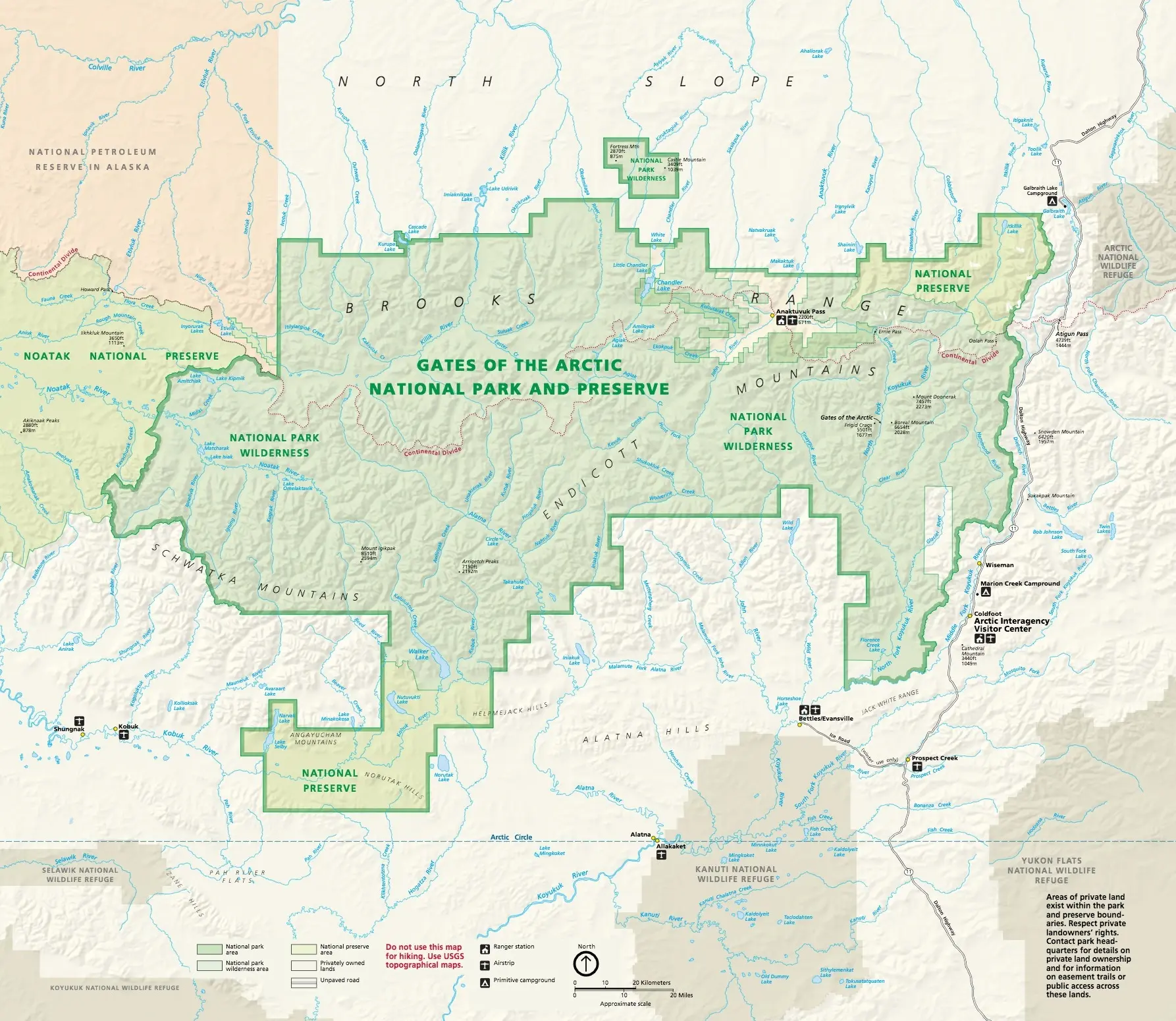
Main Areas Shown on the Map
Brooks Range
The Brooks Range dominates the center of the park.
This mountain chain contains:
- Rugged peaks
- Broad alpine valleys
- Glacier-carved landscapes
- Remote passes
The famous “Gates of the Arctic” refers to two mountains framing the North Fork of the Koyukuk River:
- Frigid Crags
- Boreal Mountain
Arrigetch Peaks
Located in the southwest portion of the park, the Arrigetch Peaks are among Alaska’s most spectacular granite mountains.
Popular for:
- Backpacking
- Photography
- Mountaineering
- Wilderness camping
Since there are no trails, visitors typically arrive by bush plane.
Anaktuvuk Pass
Situated within the Brooks Range, Anaktuvuk Pass is one of the few permanent communities associated with the park.
The area serves as:
- Cultural center for the Nunamiut people
- Gateway for some hiking expeditions
- Access point via small aircraft
Koyukuk River
One of Alaska’s major rivers, the Koyukuk flows through portions of the park.
Popular activities include:
- Packrafting
- Canoeing
- Fishing
- Wildlife viewing
Alatna River
The Alatna River is one of the park’s classic wilderness float routes.
Many backcountry visitors combine:
- Bush plane drop-off
- Multi-day river trip
- Bush plane pickup
Noatak River
Near the western boundary, the Noatak River is another internationally recognized wilderness river.
Although much of it lies within Noatak National Preserve, many expeditions combine visits to both parks.
There Are No Park Entrances
One of the most unique features you’ll notice on the map is the complete absence of entrance stations.
Unlike Yellowstone or Yosemite, Gates of the Arctic has:
- No entrance gate
- No entrance road
- No entrance booths
- No fee station
Main access points to Gates of the Arctic National Park
| Access Point | Description |
|---|---|
| Bettles (Most Popular Gateway) | The primary gateway for backpackers and float trips. Visitors typically fly from Fairbanks to Bettles, then take an air taxi into the park. |
| Anaktuvuk Pass | A remote Nunamiut village on the eastern side of the Brooks Range. Visitors can fly here and hike directly into the park. |
| Coldfoot / Dalton Highway | The closest road access. Visitors drive the Dalton Highway to Coldfoot or Galbraith Lake, then backpack several miles into the park. There are no maintained trails. |
Access Points Shown Near the Park
Although there are no official entrances, maps usually highlight several important access communities.
Fairbanks
Most visitors begin here.
Fairbanks offers:
- Commercial flights
- Hotels
- Gear stores
- Bush flight operators
- National Park Service information
Coldfoot
Located along the Dalton Highway.
Coldfoot provides:
- Fuel
- Lodging
- Air taxi services
- Last supplies before entering the Arctic
Bettles
Bettles is one of the primary air gateways into the park.
Visitors commonly charter bush planes from Bettles to reach:
- Arrigetch Peaks
- Alatna River
- Kobuk River
- Remote lakes
Wiseman
A small historic village near Coldfoot.
Some guided hiking trips begin here before entering the park.
Anaktuvuk Pass
Accessible only by aircraft, this village offers another route into the central Brooks Range.
Major Rivers on the Map
Important rivers include:
- Alatna River
- John River
- North Fork Koyukuk River
- Middle Fork Koyukuk River
- Noatak River
- Kobuk River (near preserve)
These rivers often function as natural travel corridors since there are no trails.
Airstrips on the Map
Several primitive airstrips appear on official maps.
These are used primarily by:
- Air taxis
- National Park Service
- Researchers
- Emergency services
- Wilderness travelers
Many visitors land directly on gravel bars or remote lakes rather than established runways.
Ranger Stations
Maps identify several ranger facilities located outside or near park boundaries.
These provide:
- Backcountry information
- Weather updates
- Safety advice
- Cultural exhibits
Most visitors receive trip information before entering the wilderness.
Wilderness Designation
Nearly the entire national park is federally designated wilderness.
Maps distinguish:
- National Park
- National Preserve
- Designated Wilderness
- Native corporation lands
Visitors should always respect private land ownership shown on official maps.
Wildlife Areas
Although wildlife cannot be predicted, maps often indicate habitats for:
- Caribou
- Dall sheep
- Moose
- Wolves
- Grizzly bears
- Black bears
Animal movements vary dramatically throughout the year.
Best Maps for Visiting
For trip planning, consider using:
- Official National Park Service map
- USGS 1:63,360 topographic maps
- USGS 1:250,000 regional maps
- National Geographic Trails Illustrated map
- GPS navigation with downloaded offline maps
Because there is no cell service across most of the park, paper maps remain essential.
Download the Official Park Map
The National Park Service provides free downloadable resources, including:
- Park brochure map (PDF)
- General overview map
- Land status map
- Anaktuvuk Pass area maps
You can download them from the official NPS Maps page:
Gates of the Arctic National Park Maps
Map Tips for First-Time Visitors
Before entering the park:
- Download offline maps before leaving Fairbanks.
- Carry a detailed topographic map and compass.
- Bring a satellite communicator, since cell service is generally unavailable.
- Understand that there are no maintained trails or directional signs.
- Plan transportation with an air taxi well in advance.
- Check weather forecasts carefully, as conditions can change rapidly.
Frequently Asked Questions
Does Gates of the Arctic have roads?
No. There are no roads within the national park, and there are no maintained hiking trails. Visitors typically arrive by bush plane or hike in from the Dalton Highway.
Can I drive into the park?
Not directly. The closest road access is the Dalton Highway, but reaching the park from there requires hiking across undeveloped terrain.
What is the best map for hiking?
The best choice is a USGS topographic map (1:63,360 scale) combined with the official National Park Service overview map.
Are GPS apps enough?
No. GPS devices are helpful, but visitors should always carry paper topographic maps because batteries can fail and there is no cellular coverage.
Is there an official park map?
Yes. The National Park Service offers a free downloadable map showing park boundaries, rivers, villages, airstrips, and major geographic features.