Bryce Canyon National Park Map: Your Complete Guide to Navigating the Park
Where is Bryce Canyon National Park?
Bryce Canyon National Park is located in southern Utah, United States, along the eastern edge of the Paunsaugunt Plateau. The park is famous for its colorful rock spires, called hoodoos, and sits at elevations ranging from about 8,000 to 9,100 feet (2,438–2,774 meters) above sea level.
Location at a glance
- State: Utah
- Region: Southern Utah
- County: Garfield County (with a small portion extending into Kane County)
- Nearest town: Bryce Canyon City (about 2 miles / 3 km from the park entrance)
- Nearest larger city: Cedar City (about 80 miles / 129 km west)
Bryce Canyon National Park Map
Click the image below to view map of Bryce Canyon National Park in full size.
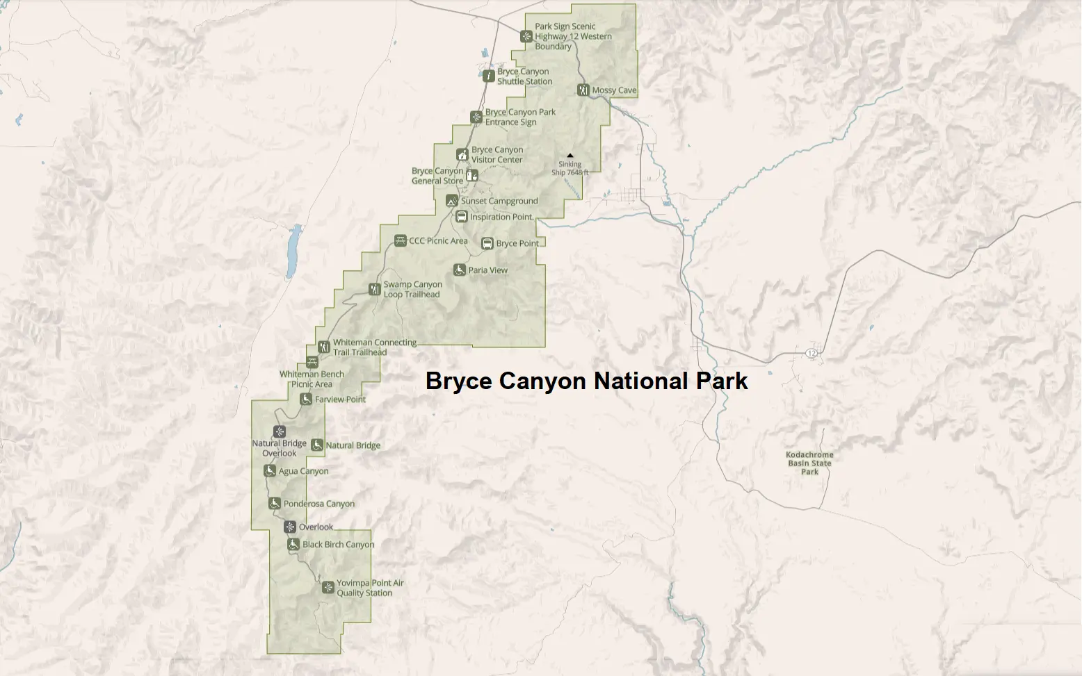
If you want to download Bryce Canyon National Park PDF file you can click here
Main Areas on the Bryce Canyon National Park Map
Park Entrance
The main entrance is located on Utah State Route 63.
After entering the park, visitors quickly reach:
- Entrance station
- Visitor Center
- Shuttle boarding area
- General store
- North Campground
This northern section receives the highest concentration of visitors.
Bryce Amphitheater
The Bryce Amphitheater is the heart of the park and the area where most visitors spend the majority of their time.
The map shows several famous overlooks located close together:
- Sunrise Point
- Sunset Point
- Inspiration Point
- Bryce Point
These viewpoints overlook the largest collection of hoodoos in the park and are connected by paved walking paths and portions of the Rim Trail.
Southern Scenic Drive
Continuing south along the main park road leads to quieter viewpoints with higher elevations and wider landscapes.
Popular stops include:
- Swamp Canyon
- Natural Bridge
- Farview Point
- Piracy Point
- Agua Canyon
- Ponderosa Canyon
- Black Birch Canyon
- Rainbow Point
- Yovimpa Point
The southern viewpoints typically receive fewer visitors than Bryce Amphitheater while offering equally stunning scenery.
Bryce Canyon Scenic Drive
The park road is approximately 18 miles (29 km) one way.
Most visitors drive directly to Rainbow Point first and then stop at viewpoints while returning north. This strategy avoids backtracking and often provides better lighting for photography throughout the day.
Driving the entire scenic road with stops generally requires 3–4 hours.
Hiking Trails on the Bryce Canyon National Park Map
The trail map is one of the most valuable parts of the park map because many trails intersect inside the amphitheater.
Popular hiking routes include:
Rim Trail
- Mostly easy
- Runs along the canyon rim
- Connects many viewpoints
- Excellent for sunrise and sunset
Distance depends on the section you choose.
Navajo Loop Trail
One of Bryce Canyon’s signature hikes.
Highlights include:
- Wall Street
- Two Bridges
- Hoodoos
- Switchbacks
The map indicates seasonal closures of Wall Street when applicable.
Queen’s Garden Trail
Often considered the easiest trail descending into the amphitheater.
Many visitors combine it with Navajo Loop to create the park’s most popular hike.
Peekaboo Loop Trail
A longer and more strenuous hike featuring:
- Towering hoodoos
- Horseback riders
- Quiet sections of the amphitheater
This trail is recommended for experienced hikers.
Fairyland Loop
Located north of the main amphitheater, Fairyland Loop receives fewer visitors and offers one of the park’s most scenic full-day hikes.
Under-the-Rim Trail
This backcountry trail stretches approximately 23 miles (37 km) through remote sections of Bryce Canyon National Park.
Bryce Canyon Campgrounds
The map identifies two developed campgrounds.
North Campground
Located near:
- Visitor Center
- General Store
- Shuttle stop
- Bryce Amphitheater
Open seasonally.
Sunset Campground
Situated close to Sunset Point.
Provides easy access to hiking trails and evening photography locations.
Reservations are recommended during peak season.
Bryce Canyon Lodge
The historic Bryce Canyon Lodge sits near Sunset Point and serves as the primary lodging facility inside the park.
Nearby map features include:
- Dining room
- Gift shop
- Parking
- Shuttle stop
- Rim Trail access
Its central location allows guests to walk directly to several viewpoints.
Bryce Canyon Visitor Center
The Visitor Center should be your first stop.
Facilities include:
- Park maps
- Ranger programs
- Current trail conditions
- Weather forecasts
- Exhibits
- Restrooms
- Bookstore
Park rangers can also recommend hikes based on available time and fitness level.
Major Viewpoints on the Map
Sunrise Point
Excellent for:
- Early morning photography
- Beginning the Queen’s Garden Trail
- Wide amphitheater views
Sunset Point
One of the park’s busiest overlooks.
Nearby highlights include:
- Thor’s Hammer
- Navajo Loop Trail
- Bryce Canyon Lodge
Inspiration Point
Offers three viewing levels overlooking Bryce Amphitheater.
Each level appears on park maps with connecting walking paths.
Bryce Point
Known for panoramic sunrise views and dramatic perspectives of the hoodoos.
Many photographers consider it one of the best viewpoints in the park.
Rainbow Point
The highest developed viewpoint in the park at approximately 9,115 feet (2,778 m) above sea level.
The area also provides access to:
- Yovimpa Point
- Bristlecone Loop Trail
Accessibility Features
Official park maps identify accessible facilities, including:
- Accessible parking
- Restrooms
- Visitor Center
- Lodge
- Selected viewpoints
- Paved walkways
Many of the rim viewpoints are wheelchair accessible.
Tips for Using the Bryce Canyon National Park Map
To get the most from your visit:
- Download an offline map before arriving.
- Mark your preferred viewpoints in advance.
- Start early to avoid crowded parking lots.
- Use the shuttle during peak summer months.
- Carry both the park map and a trail map when hiking.
- Pay attention to elevation, as Bryce Canyon ranges from about 8,000 to over 9,000 feet above sea level.
- Always check trail closures at the Visitor Center before beginning a hike.
Frequently Asked Questions
Is Bryce Canyon National Park easy to navigate?
Yes. The park is centered around one main scenic road, making navigation relatively simple. A detailed park map helps visitors locate viewpoints, hiking trails, campgrounds, and visitor facilities efficiently.
How long does it take to drive through Bryce Canyon National Park?
Driving from the entrance to Rainbow Point takes about 35–45 minutes without stops. Most visitors spend 3–4 hours exploring the scenic drive and overlooks.
Can I get a free Bryce Canyon National Park map?
Yes. Free maps are available at the park entrance, the Visitor Center, and on the National Park Service website as downloadable PDFs.
Is the Bryce Canyon shuttle free?
Yes. The Bryce Canyon shuttle is free to all park visitors during its operating season and serves the most heavily visited areas of the park.
Which viewpoint should I visit first?
If you plan to drive the scenic road, many visitors head directly to Rainbow Point first and stop at overlooks on the return trip. If you’re hiking in Bryce Amphitheater, Sunrise Point or Sunset Point are excellent starting locations.
Final Thoughts
A Bryce Canyon National Park map is one of the most useful planning tools for any visit. It helps you understand the park’s layout, compare hiking options, locate scenic overlooks, and estimate travel times between destinations. Whether you’re exploring the famous Bryce Amphitheater, hiking beneath the hoodoos, or driving the full scenic road to Rainbow Point, keeping a map handy ensures you spend less time navigating and more time enjoying one of Utah’s most remarkable landscapes.