Zion National Park Map Guide
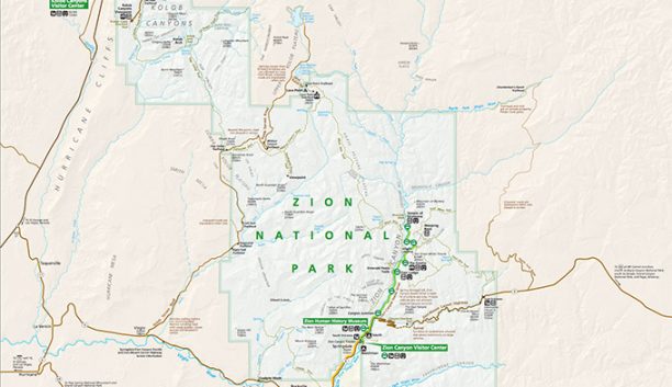
Getting to Zion National Park
The closest major airport is Salt Lake City International Airport is 309 miles North of the park.
The Saint George Airport is 46 miles South of Zion National Park.
From the North
1. Take I-15 South to Exit 40 to Zion National Park.
2. Or continue South on I-15 to Exit 27 onto Stateroad 17 East to Stateroad 9 to Zion.
3. Or continue South on I-15 to Exit 16 onto Stateroad 9 East to Zion.
From the East
1. Take I-70 West to I-15 South and then follow one of the three directions above.
2. Take I-70 West to Exit 48 onto Highway 89 South to Stateroad 9 West to Zion.
From the West
1. Head to I-15 North or South and follow the North or South directions to the park.
From the South
1. Head to I-15 North to Exit 16 onto Stateroad 9 East to the park.
2. Head to Highway 89 North to Stateroad 9 West to Zion.

