Exploring the Impact of Satellite Imagery on National Park Conservation
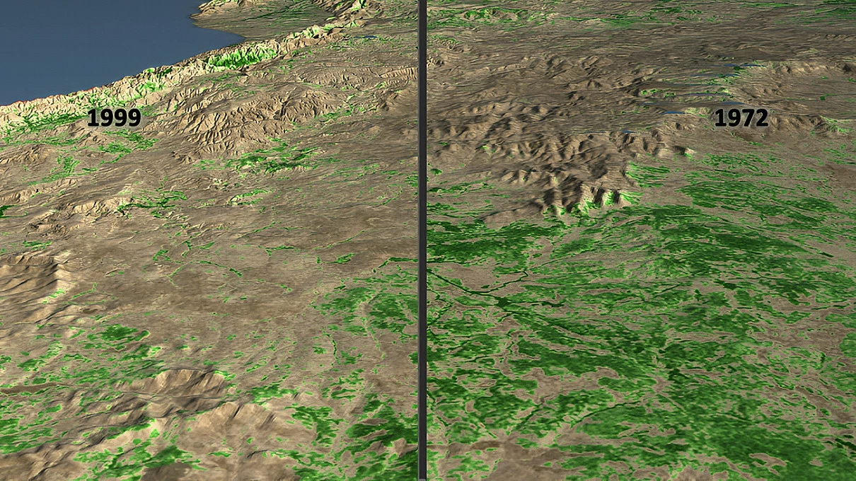
Landsat images compare the forest cover change between 1972 and 1999 in the region around Gombe National Park. Image Credit: NASA/Goddard Scientific Visualiztion Studio/Cindy Starr
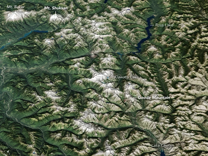
In conservation, perspective is key. Satellites offer a unique overview of ecosystems, allowing ecologists to evolve from traditional methods to data-driven approaches.
In national parks, current and historical satellite imagery is essential for tracking changes in landscapes and ecosystems. This technology streamlines conservation efforts, combining algorithms and machine learning to create effective preservation strategies. This innovative approach is just the beginning of its potential in environmental protection. Let’s learn more about it.
Monitoring Environmental Changes
The ability to view historical satellite images offers more than just a breathtaking view of national parks; it’s a powerful tool for understanding how these landscapes are changing over time. Satellites act as unbiased observers, providing insights that were once hard to obtain.
For instance, detecting illegal logging in remote areas has become precise, with satellite technology identifying hotspots of deforestation in the Amazon, allowing for swift intervention. Additionally, satellites monitor soil erosion and desertification, highlighting regions in need of restoration.
Consequences of flooding in the Yellowstone National Park, Wyoming, the U.S. with Sentinel 2 using Color Infrared (Vegetation) band combination. Credit: EOSDA
Wildlife habitats also benefit from this technology. As climate change and human activities shift species, satellites help ecologists track these movements. A notable example is the discovery of a hidden colony of 1.5 million Adélie penguins in Antarctica, revealed through space imagery analysis.
Satellite monitoring is revolutionizing conservation efforts in remarkable ways:
1. Consistent Insights. Satellites deliver reliable data, enabling tracking of plastic waste in areas as small as 5×5 meters, allowing for rapid responses to pollution.
2. Quick Assessments. Satellites reveal that Earth has lost 4,000 km² of tidal wetlands in two decades, a feat that would take generations through ground surveys.
3. Accessing the Unreachable. Satellites can explore remote areas like Antarctica and dense forests, uncovering hidden ecosystems.
4. Precision Without Disturbance. Unlike human surveys, satellite imagery minimizes errors and avoids disrupting delicate ecosystems.
5. Seamless Monitoring. Satellites facilitate cross-border conservation by bypassing bureaucratic hurdles, enabling efficient monitoring of transnational regions.
Overall, satellites enhance conservation by detecting even minor environmental changes, proving that observing from above can be one of the most effective ways to protect our planet.
Managing Wildfires
Wildfires are nature’s way of hitting the reset button, but when left unchecked, they can turn national parks into smoldering wastelands. Space imagery provides near real-time data on active fires and aids in prevention, management, and recovery.
Remote sensing addresses wildfires in three ways:
1. Detection. Real-time satellite imagery reveals active fires in remote areas, enabling faster response.
2. Damage Assessment. After fires, satellites help evaluate destruction, keeping people safe from hazardous terrain.
3. Prevention. By analyzing fire patterns from satellite historical imagery, experts identify high-risk areas, informing mitigation strategies to protect ecosystems and communities.
The Northern Colorado Plateau illustrates how wildfires, while smaller than in other Western regions, can still cause significant ecological changes. Some NCP parks use prescribed burns to reduce excess fuel, making wildfires less catastrophic and more beneficial to ecosystems, thus preventing soil damage and erosion.
At Bryce Canyon National Park, NCPN staff monitored a prescribed fire and a lightning-caused wildfire using satellite technology, tracking recovery over time. Space imagery revealed that the intense wildfire left soil exposed, leading to erosion and hindering ecosystem restoration. In contrast, the controlled prescribed burn, which occurred in an area with denser vegetation, burned less intensely and allowed for quicker recovery.
Terrestrial Protected
Managing protected land areas is challenging due to vast landscapes, hidden wildlife, and rising human activities. High-resolution satellite imagery is revolutionizing conservation efforts. By integrating Airbus Foundation remote sensing technology with AI insights from partners like NTT Ltd., conservationists are enhancing ecosystem protection.
A major advancement is locating endangered species in remote areas. Satellites equipped with AI can identify wildlife hotspots and track species movements, creating “wildlife heat maps” that help conservation teams target their efforts effectively.
Satellites also collect vital ecosystem data, mapping water sources and grasslands while monitoring invasive species, which aids in developing management plans for climate-related changes. This results in more effective strategies benefiting both conservation and local communities.
Additionally, poaching is monitored from above. At Madikwe Game Reserve, high-resolution images helped identify rhino carcasses, supporting investigations and bolstering anti-poaching efforts.
Road monitoring is another benefit. Annual space images update reserve maps, balancing tourism and environmental protection, while detecting unauthorized roads that may indicate poaching or resource extraction. Data-driven decisions on road management can now be made.
With satellite technology, land conservation is evolving from reactive to proactive, combining advanced tools with active management to safeguard vulnerable terrains.
Promoting Sustainable Tourism
Sustainable tourism requires careful management: attracting visitors to enjoy nature’s beauty while protecting the environment. Current and historical satellite images of a location provide a unique view, assisting parks in managing tourism effectively.
For example, park supervisors can use satellite data to monitor tourist movements, uncovering trends that might be missed otherwise. This technology helps identify worn-out trails and areas under stress, ensuring that protection remains a priority alongside exploration.
Remote sensing also plays a crucial role in planning infrastructure. By studying the land and ecosystems, park managers can design new facilities — such as roads, rest areas, or viewing spots — while minimizing environmental impact.
When tourism takes its toll, satellites help direct restoration efforts by locating damaged areas. Whether it’s fixing a popular meadow or replanting trees along worn paths, satellite data ensures that recovery efforts are focused and effective.
With this data-driven strategy, national parks can host visitors while preserving their ecosystems. The aim is for nature’s beauty to inspire future generations, not just today’s tourists.
Rethinking Conservation
Recent and historical satellite imagery is transforming preservation efforts in national parks by revealing hidden wildlife and illegal activities. This technology provides critical insights into ecosystems and human impacts, enabling ecologists to take effective action — whether assessing wildfire recovery in Bryce Canyon or monitoring rhino movements.
As climate change and human activity pose increasing challenges, satellites offer a vital aerial perspective that helps ensure our parks not only survive but thrive. In safeguarding our planet, a higher vantage point is essential for understanding the full scope of the situation.
______________
Author: Peter Kogut

Petro Kogut has a PhD in Physics and Mathematics and is the author of multiple scientific publications. Among other topics, he has a specific focus on a satellite imagery processing and application in his academic research. Currently, Prof. Dr. Petro Kogut also works a science advisor.
