Everglades National Park Map and Entrances Explained
Everglades National Park covers more than 1.5 million acres across southern Florida, making it one of the largest and most unique national parks in the United States. Unlike many national parks, the Everglades doesn’t have a single scenic drive connecting all major attractions. Instead, the park is divided into three separate entrances, each leading to different ecosystems, trails, and visitor experiences. Understanding an Everglades National Park map before your visit can save hours of driving and help you plan the perfect itinerary.
Everglades National Park Map
Click the image below to view map of Everglades National Park in full size.
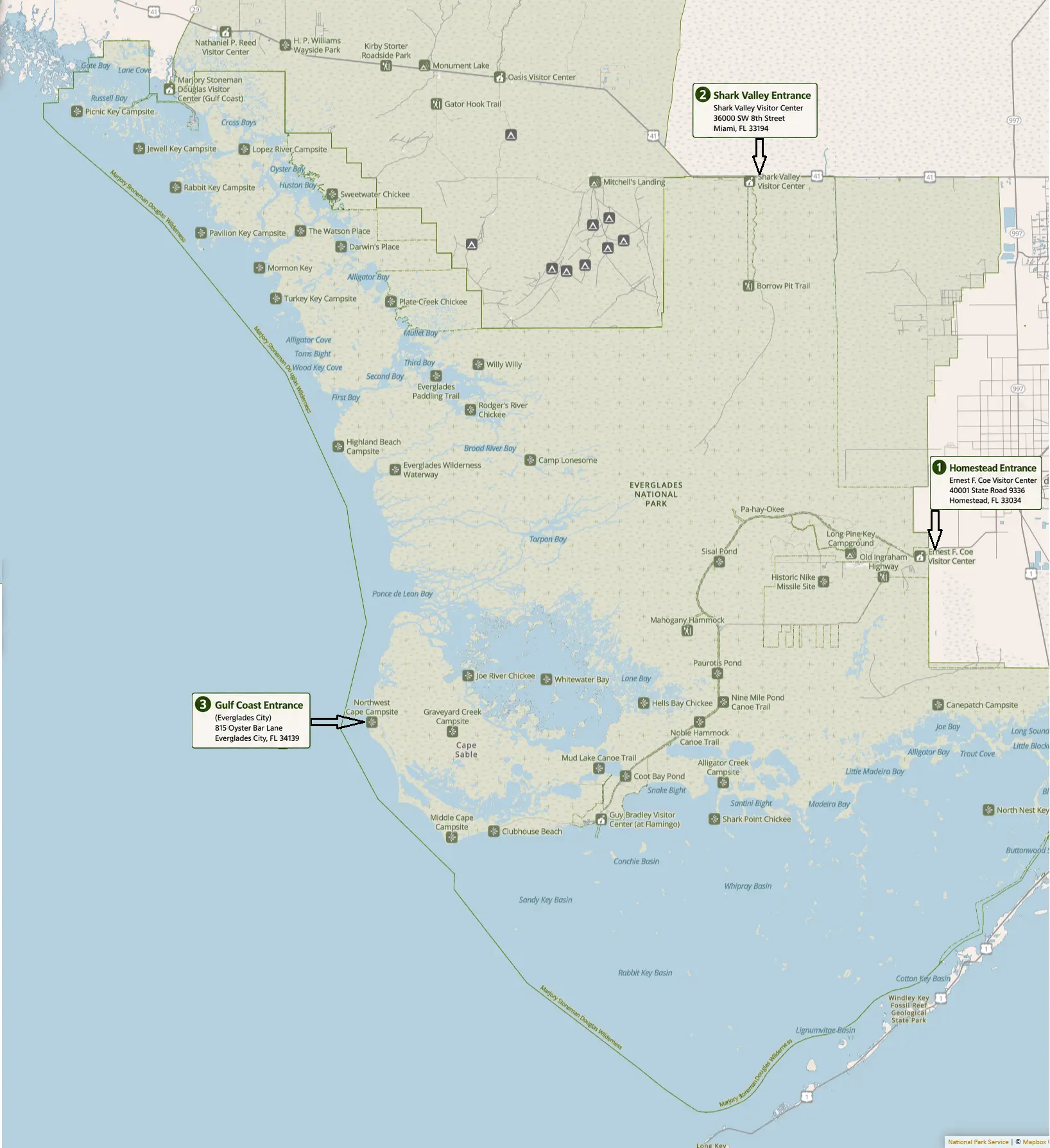
Everglades National Park has three main entrances, and they do not connect by road. You cannot drive from one entrance to another through the park, so choose the entrance based on what you want to see.
1. Homestead Entrance (Main Entrance)
- Location: 40001 State Road 9336, Homestead, FL
- Closest city: Homestead (about 1 hour from downtown Miami)
- Visitor Center: Ernest F. Coe Visitor Center
- Best for:
- Anhinga Trail
- Royal Palm
- Flamingo
- Eco Pond
- Camping, kayaking, boat tours, and the Flamingo Lodge
- Open: 24 hours (entrance road)
Highlights include:
- Ernest F. Coe Visitor Center
- Royal Palm Area
- Anhinga Trail
- Gumbo Limbo Trail
- Mahogany Hammock
- Pa-hay-okee Overlook
- Flamingo Visitor Area
This entrance provides access to the famous 38-mile Main Park Road, ending at Flamingo on Florida Bay. Along the drive are numerous short boardwalks and scenic overlooks perfect for wildlife photography.
This is the best entrance if you’re visiting Everglades National Park for the first time.
2. Shark Valley Entrance
- Location: 36000 SW 8th Street (US-41/Tamiami Trail), Miami, FL
- Closest city: Miami
- Visitor Center: Shark Valley Visitor Center
- Best for:
- 15-mile paved loop trail
- Observation Tower
- Wildlife viewing (especially alligators and birds)
- Bicycle rentals
- Tram tours
- Gate hours: Typically 8:30 AM–6:00 PM (visitor center hours may vary).
Popular attractions include:
- Shark Valley Visitor Center
- 15-mile paved loop trail
- Observation Tower
- Bicycle rentals
- Guided tram tours
Despite its name, Shark Valley contains no sharks. The area is famous for alligators, turtles, wading birds, and panoramic views across the “River of Grass.”
3. Gulf Coast Entrance (Everglades City)
Location: 815 Oyster Bar Lane, Everglades City, FL
Closest city: Everglades City (near Naples)
Area: Ten Thousand Islands
Best for:
- Boat tours
- Kayaking
- Canoeing
- Fishing
- Backcountry adventures
Main attractions include:
- Mangrove forests
- Canoe trails
- Kayaking routes
- Boat tours
- Ten Thousand Islands
Unlike the Homestead entrance, there are few hiking trails here. Most visitors come to paddle or take guided boat excursions.
Note: The Gulf Coast Visitor Center is currently under construction, but the Ten Thousand Islands area remains accessible by boat.
Which entrance should you choose?
| If you want to… | Best entrance |
|---|---|
| Visit the main attractions and Flamingo | Homestead (Main Entrance) |
| See lots of alligators and take a tram or bike ride | Shark Valley |
| Explore mangroves and the Ten Thousand Islands by boat | Gulf Coast (Everglades City) |
Important Tips
- The three entrances are not connected internally—plan your day around a single entrance.
- Download offline maps before visiting because cell service is limited in many areas.
- During the busy winter season, arriving before 10:00 AM can help avoid long entrance lines and parking issues.
Everglades National Park Map of Major Attractions
Below are the primary destinations you’ll typically find marked on the park map.
Ernest F. Coe Visitor Center
The park’s primary information center offers:
- Maps
- Ranger programs
- Exhibits
- Restrooms
- Park store
Most visitors begin their adventure here before driving deeper into the park.
Royal Palm
One of the most visited areas because wildlife is abundant year-round.
Features include:
- Anhinga Trail
- Gumbo Limbo Trail
- Boardwalks
- Alligator viewing
- Bird watching
Walking distance:
- Anhinga Trail: 0.8 miles round-trip
- Gumbo Limbo Trail: 0.4 miles
Long Pine Key
Located a short drive from the main entrance, Long Pine Key offers:
- Campground
- Pine rockland habitat
- Hiking trails
- Fishing opportunities
Mahogany Hammock
A favorite stop on the drive toward Flamingo.
Highlights:
- Elevated boardwalk
- Largest living mahogany trees in the U.S.
- Tropical hardwood forest
- Excellent shade
Pa-hay-okee Overlook
One of the best scenic viewpoints in the park.
Visitors enjoy:
- Elevated observation deck
- Panoramic marsh views
- Sunrise photography
- Bird watching
Flamingo
Located at the southern end of the Main Park Road.
Attractions include:
- Marina
- Boat tours
- Kayak rentals
- Campground
- Florida Bay views
- Manatee sightings
- Crocodiles
Flamingo is nearly 38 miles from the Homestead entrance, so allow about an hour of driving plus stops.
Everglades National Park Road Map
The primary road network is simple compared to most national parks.
Main Park Road
Runs from:
Homestead Entrance → Royal Palm → Long Pine Key → Mahogany Hammock → Flamingo
Distance:
- Approximately 38 miles one way
Driving time without stops:
- About one hour
Shark Valley Loop Road
- 15-mile paved loop
- Closed to private vehicles
- Open for:
- Walking
- Biking
- Tram tours
Halfway through the loop sits the famous Shark Valley Observation Tower.
Best Hiking Trails on the Map
| Trail | Distance | Difficulty | Best For |
|---|---|---|---|
| Anhinga Trail | 0.8 mi | Easy | Alligators |
| Gumbo Limbo Trail | 0.4 mi | Easy | Tropical forest |
| Mahogany Hammock | 0.5 mi | Easy | Huge mahogany trees |
| Pineland Trail | 0.9 mi | Easy | Pine ecosystem |
| Pa-hay-okee Trail | 0.2 mi | Easy | Scenic overlook |
| Coastal Prairie Trail | 15 mi round-trip | Difficult | Remote hiking |
Wildlife Hotspots
If wildlife is your priority, these locations deserve special attention.
Best for Alligators
- Anhinga Trail
- Shark Valley Loop
Best for Birds
- Royal Palm
- Flamingo
- Eco Pond
Best for Crocodiles
- Flamingo Marina
Best for Manatees
- Flamingo Marina
- Florida Bay
Best for Turtles
- Shark Valley
- Anhinga Trail
Suggested One-Day Routes
Option 1: First-Time Visitors
Start at Homestead.
Stops:
- Ernest F. Coe Visitor Center
- Royal Palm
- Anhinga Trail
- Gumbo Limbo
- Mahogany Hammock
- Pa-hay-okee
- Flamingo
Option 2: Wildlife Lovers
Visit Shark Valley.
Activities:
- Bike the loop
- Observation Tower
- Tram tour
- Wildlife photography
Option 3: Water Adventures
Choose Gulf Coast.
Activities:
- Kayaking
- Canoeing
- Boat tours
- Mangrove tunnels
Tips for Using an Everglades National Park Map
- Download an offline map before arriving because cell service is limited in many areas.
- Do not plan to drive between entrances through the park—they are not connected.
- Allow extra time for wildlife viewing and frequent stops.
- Carry plenty of water, especially during warmer months.
- Bring binoculars for birdwatching.
- Use insect repellent during the wet season.
- Check current road and trail conditions before your visit.
Frequently Asked Questions
Is there one road through Everglades National Park?
No. The Homestead, Shark Valley, and Gulf Coast sections are separate and cannot be connected by driving within the park.
Which entrance should first-time visitors use?
The Homestead Entrance is generally the best choice because it provides access to the park’s most famous trails, visitor center, and Flamingo area.
Can I drive from Shark Valley to Flamingo?
No. You’ll need to leave the park and drive via public highways because the entrances are not internally connected.
Where can I see the most wildlife?
The Anhinga Trail, Royal Palm, Shark Valley Loop, and Flamingo are among the best wildlife-viewing areas.
Is the Everglades easy to navigate?
Yes. The park roads are straightforward, but the three entrance areas are widely separated. A good map and advance planning make navigation simple.
Final Thoughts
An Everglades National Park map is one of the most valuable planning tools for visitors. Because the park’s entrances are separated and each offers a distinct experience, choosing the right area before you arrive can dramatically improve your trip. Whether you’re hiking boardwalks at Royal Palm, cycling through Shark Valley, or paddling the mangrove waterways of the Gulf Coast, understanding the park layout ensures you’ll spend less time driving and more time exploring one of America’s most remarkable natural landscapes.