Cuyahoga Valley National Park Map
Cuyahoga Valley National Park is one of the most unique national parks in the United States. Unlike many parks with a single entrance gate and one main road, Cuyahoga Valley stretches for more than 20 miles between Cleveland and Akron, Ohio. A good map is essential for planning your visit, helping you locate trailheads, waterfalls, visitor centers, scenic railroad stations, and picnic areas.
Whether you’re visiting for a few hours or spending an entire weekend exploring, this guide explains how to read the Cuyahoga Valley National Park map and highlights the park’s most important destinations.
Cuyahoga Valley National Park Map Overview
Click the image below to view map of Cuyahoga Valley National Park in full size.
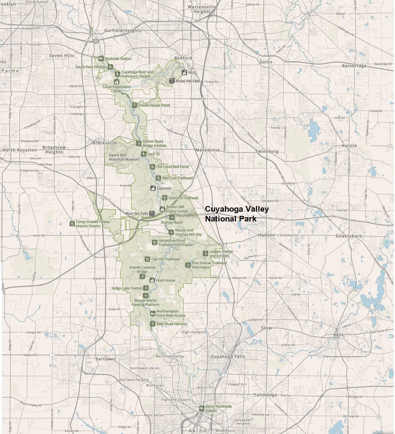
The park follows the winding Cuyahoga River, preserving forests, wetlands, waterfalls, historic canal structures, and miles of hiking and biking trails.
Unlike parks such as Yellowstone or Yosemite, there is no entrance gate. Instead, visitors access different sections of the park via local roads connecting Cleveland and Akron.
A typical park map includes:
- Park boundaries
- Visitor centers
- Major roads
- Hiking trails
- Scenic railroad stations
- Waterfalls
- Campgrounds (outside the park)
- Picnic areas
- Historic canal sites
- Parking lots
- Bicycle routes
- Restrooms
Understanding the Park Layout
The park runs roughly north to south through northeastern Ohio.
Northern Section
The northern part of the park is closest to Cleveland and contains:
- Canal Exploration Center
- Towpath Trail
- Rockside Station
- Historic Ohio & Erie Canal
- Scenic railroad access
This area is popular for biking, walking, and learning about the canal’s history.
Central Section
The central area is where many first-time visitors begin.
Highlights include:
- Boston Mill Visitor Center
- Blue Hen Falls
- Stanford Trail
- Brandywine Falls
- Station Road Bridge
- Red Lock Trailhead
This section offers the greatest concentration of hiking opportunities.
Southern Section
The southern end of the park includes:
- Ledges Trail
- Pine Hollow
- Oak Hill Trailhead
- Hunt House
- Beaver Marsh
- Indigo Lake
- Everett Covered Bridge
These areas are excellent for longer hikes and photography.
Main Visitor Areas on the Map
Boston Mill Visitor Center
Located near the center of the park, Boston Mill Visitor Center is the best starting point for first-time visitors.
Here you’ll find:
- Park information
- Trail maps
- Ranger programs
- Restrooms
- Parking
- Gift shop
Brandywine Falls
One of the park’s most famous attractions, Brandywine Falls features a spectacular 65-foot waterfall accessible via a short boardwalk trail.
Nearby parking fills quickly during weekends.
Canal Exploration Center
Located in the northern section, this historic building explains the importance of the Ohio & Erie Canal and provides easy access to the Towpath Trail.
Ledges Area
The Ledges Trail is one of the park’s most scenic hikes, featuring sandstone cliffs, moss-covered rock formations, and outstanding sunset viewpoints.
Beaver Marsh
A favorite location for wildlife viewing, Beaver Marsh offers a flat boardwalk where visitors frequently spot:
- Great blue herons
- Beavers
- Turtles
- River otters
- Songbirds
Hiking Trails on the Map
Popular hiking trails include:
| Trail | Distance | Difficulty |
|---|---|---|
| Brandywine Gorge Trail | 1.5 miles | Moderate |
| Ledges Trail | 2.2 miles | Moderate |
| Blue Hen Falls Trail | 3 miles round trip | Easy |
| Towpath Trail | Up to 87 miles | Easy |
| Kendall Lake Loop | 1.7 miles | Easy |
| Pine Grove Trail | 2.2 miles | Moderate |
Most trailheads are clearly marked on the park map.
Scenic Drives
Several scenic roads connect different parts of the park.
Popular driving routes include:
- Riverview Road
- Akron Peninsula Road
- Boston Mills Road
- State Route 303
- State Route 82
Unlike many western national parks, the roads remain open year-round except during severe winter weather.
Cuyahoga Valley Scenic Railroad
The map also shows stations for the Cuyahoga Valley Scenic Railroad, one of the park’s most unique attractions.
Popular boarding stations include:
- Rockside Station
- Peninsula Depot
- Akron Northside Station
Many visitors bike one direction along the Towpath Trail and return by train.
Biking the Towpath Trail
The Ohio & Erie Canal Towpath Trail is one of the park’s signature attractions.
The paved and crushed-limestone trail is suitable for:
- Families
- Casual cyclists
- Long-distance riders
- Walkers
- Joggers
Bike rentals are available near Peninsula.
Park Entrances
Unlike many U.S. national parks, Cuyahoga Valley National Park does not have a single main entrance or entrance gate. The park stretches for more than 20 miles between Cleveland and Akron, Ohio, with numerous access points along public roads. There is no entrance fee and visitors can enter from many different locations.
The most commonly used access points are:
- Boston Mill Visitor Center (Main Visitor Area)
- Address: 6947 Riverview Rd, Peninsula, OH 44264
- Best for: First-time visitors, park information, maps, and ranger assistance.
- Closest highways: OH-303 and Riverview Road.
- Brandywine Falls Entrance
- Address: 8176 Brandywine Rd, Sagamore Hills, OH 44067
- Best for: Brandywine Falls, one of the park’s most popular attractions.
- Canal Exploration Center (North Entrance)
- Address: 7104 Canal Rd, Valley View, OH 44125
- Best for: Ohio & Erie Canal history, Towpath Trail, and northern park access.
- Hunt House (South Entrance)
- Address: 4524 Quick Rd, Peninsula, OH 44264
- Best for: Southern trails and seasonal visitor information.
- Station Road Bridge Trailhead
- Address: 1550 Riverview Rd, Brecksville, OH 44141
- Best for: Towpath Trail, biking, kayaking, and the Cuyahoga Valley Scenic Railroad.
Which entrance should you use?
- Coming from Cleveland: Canal Exploration Center or Brandywine Falls.
- Coming from Akron: Boston Mill Visitor Center or Hunt House.
- For hiking: Boston Mill Visitor Center, Ledges Trail, or Brandywine Falls.
- For cycling: Station Road Bridge Trailhead or Canal Exploration Center.
Because the park has many entry points and no entrance stations, it’s best to choose the access point closest to the attraction you plan to visit rather than searching for a “main gate.”
Parking Information
Parking lots are available throughout the park.
Popular parking areas include:
- Boston Mill Visitor Center
- Brandywine Falls
- Ledges Trailhead
- Station Road Bridge
- Canal Exploration Center
- Everett Road
- Pine Hollow
Parking is free but fills quickly during weekends, holidays, and fall foliage season.
Best Time to Visit
Each season offers a different experience.
Spring
- Wildflowers
- Waterfalls at peak flow
- Mild temperatures
Summer
- Green forests
- Railroad excursions
- Family-friendly biking
Fall
The most popular season thanks to brilliant autumn foliage.
Peak colors usually occur during October.
Winter
Visitors enjoy:
- Snow-covered forests
- Cross-country skiing
- Quiet hiking trails
- Frozen waterfalls
Nearby Cities
The park is conveniently located near several cities:
| City | Distance |
|---|---|
| Cleveland | 20 miles |
| Akron | 10 miles |
| Canton | 40 miles |
| Columbus | 125 miles |
| Pittsburgh | 130 miles |
Tips for Using the Park Map
- Download the map before arriving, as cell service can be inconsistent in some wooded areas.
- Choose the trailhead closest to the attraction you want to visit.
- Plan extra time if you intend to explore both the northern and southern sections of the park.
- Arrive early during weekends to secure parking at popular destinations like Brandywine Falls and the Ledges.
- Carry water, especially if hiking multiple trails in one day.
Frequently Asked Questions
Is there one main entrance to Cuyahoga Valley National Park?
No. The park has multiple access points and no entrance gate.
Is there an entrance fee?
No. Admission to Cuyahoga Valley National Park is free.
What is the best place to start?
Boston Mill Visitor Center is the recommended starting point for first-time visitors.
Can I drive through the entire park?
Yes. Several public roads connect the northern and southern sections, making it easy to explore by car.
Is the official map free?
Yes. The National Park Service provides a free printable map and digital PDF that you can download before your visit.
Conclusion
A Cuyahoga Valley National Park map is the best tool for navigating this long, linear park between Cleveland and Akron. It helps visitors locate major attractions such as Brandywine Falls, Boston Mill Visitor Center, the Towpath Trail, the Ledges, Beaver Marsh, and the Cuyahoga Valley Scenic Railroad. Since there is no single entrance gate, reviewing the map in advance allows you to choose the most convenient access point, save driving time, and make the most of your visit to one of Ohio’s most beautiful national parks.