Crater Lake National Park Map and Entrances Explained
Crater Lake National Park Map Overview
The park covers 183,224 acres in southern Oregon and is centered around the magnificent Crater Lake, which fills the caldera of Mount Mazama.
Click the image below to view map of Crater Lake National Park in full size.
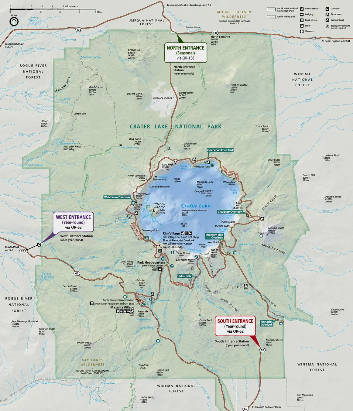
If you want to download Crater Lake National Park map PDF file you click here
Crater Lake National Park Entrances
Crater Lake National Park has three official entrances, each providing access to different parts of the park. Which entrance you should use depends on where you’re driving from and the season.
| Entrance | Highway | Best For | Open |
|---|---|---|---|
| South Entrance | OR-62 | Visitors from Klamath Falls and California | Year-round |
| West Entrance | OR-62 | Visitors from Medford and southern Oregon | Year-round |
| North Entrance | OR-138 | Visitors from Bend, Eugene, Portland, and Roseburg | Seasonal (typically mid-May/late June through October) |
The North Entrance closes each winter due to heavy snowfall, while the South and West Entrances remain open throughout the year, although chains or winter tires may be required during snowy conditions.
1. South Entrance
- Highway: Oregon Highway 62
- Nearest city: Klamath Falls (about 60 miles)
- Best for: Travelers arriving from southern Oregon, Northern California, or Highway 97.
- Open: Year-round
The South Entrance is the park’s primary entrance during winter. After entering, it’s about 7 miles (11 km) to Rim Village, where you’ll find spectacular views of Crater Lake, visitor services, and the historic Crater Lake Lodge.
2. West Entrance
- Highway: Oregon Highway 62
- Nearest city: Medford (about 75 miles)
- Best for: Visitors flying into Rogue Valley International–Medford Airport or driving from Interstate 5.
- Open: Year-round
This is the fastest entrance for travelers coming from western Oregon or northern California via Medford. During summer, it’s one of the busiest routes into the park.
3. North Entrance
- Highway: Oregon Highway 138
- Nearest city: Roseburg (approximately 95 miles)
- Also convenient from: Bend, Eugene, and Portland
- Open: Seasonal only
The North Entrance usually opens sometime between mid-May and late June, depending on snowfall, and closes around November 1 or earlier if significant snow arrives. Always check current road conditions before planning your visit.
Which Entrance Should You Use?
- From Medford: West Entrance
- From Klamath Falls: South Entrance
- From Bend: North Entrance (summer) or South Entrance (winter)
- From Portland or Eugene: North Entrance in summer; South Entrance when the North Entrance is closed.
- From California (I-5): West Entrance or South Entrance, depending on your route.
Seasonal Tips
- No vehicle reservations are required to enter Crater Lake National Park.
- Entrance fees or a valid National Park Pass are required.
- Winter visitors should expect snow, carry chains if required, and check road conditions before traveling.
- The park receives an average of over 40 feet (13.5 m) of snow annually, making seasonal road closures common.