Congaree National Park Map and Entrances Explained
Congaree National Park Map
Click the image below to view map of Congaree National Park in full size.
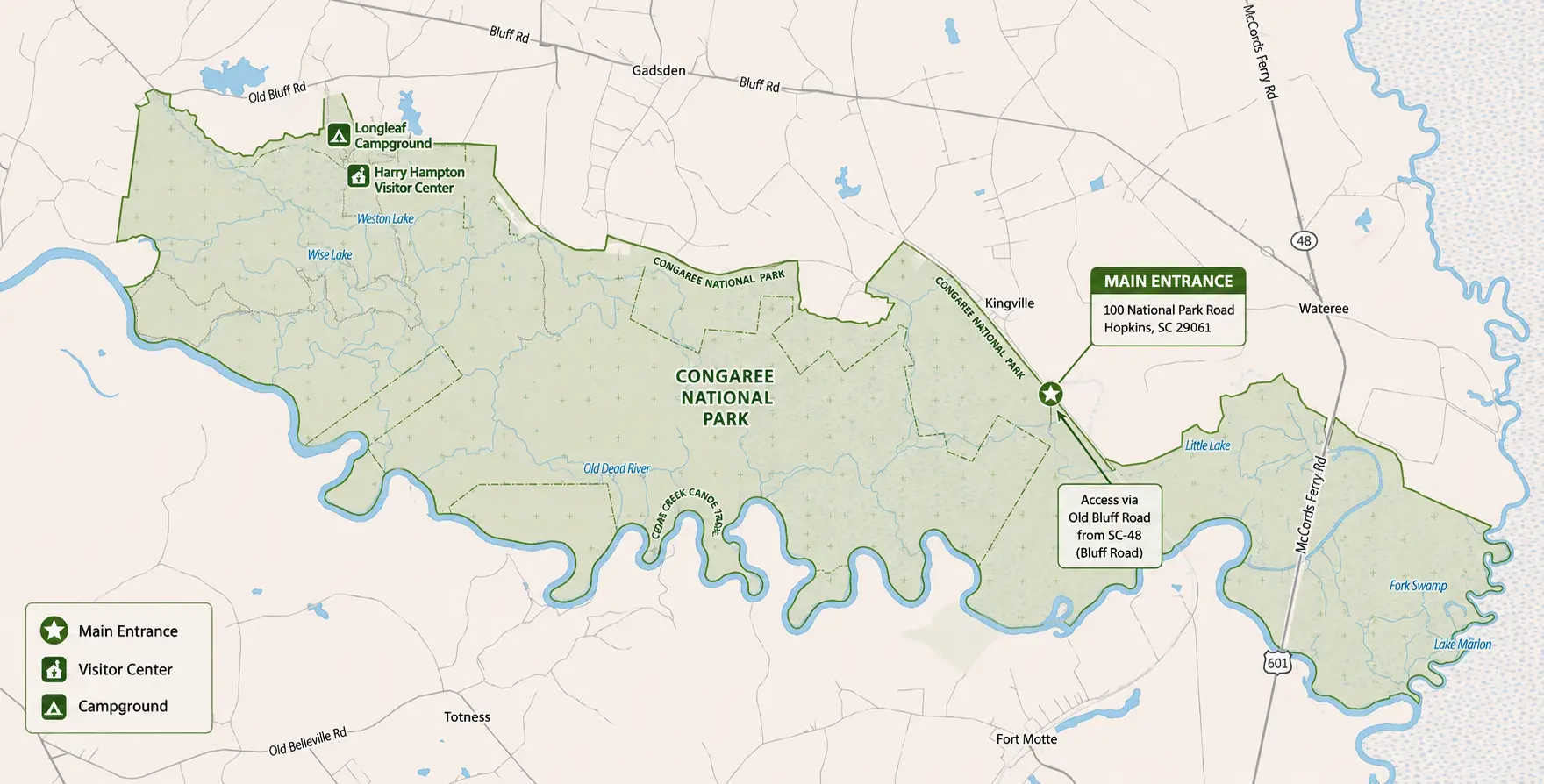
If you want to download Congaree National Park map PDF file you click here
Congaree National Park Entrances
Unlike many U.S. national parks, Congaree National Park has just one public road entrance for visitors.
Main Entrance
- Address: 100 National Park Road, Hopkins, SC 29061
- GPS Coordinates: Approximately 33.7919, -80.7487
- Access: Via Old Bluff Road from SC Highway 48 (Bluff Road).
- Destination: The entrance leads directly to the Harry Hampton Visitor Center, the main parking area, the Boardwalk Loop Trail, picnic areas, and Cedar Creek canoe launch.
Driving Directions
From Columbia, South Carolina (about 30 minutes)
- Take I-77 South to Exit 5 (SC-48/Bluff Road).
- Follow Bluff Road (SC-48 East) for approximately 8 miles.
- Turn slightly right onto Old Bluff Road.
- Continue for about 4.5 miles to the park entrance.
- Drive another mile to the visitor center parking lot.
Is There a North or South Entrance?
No. Congaree National Park does not have multiple vehicle entrances like many larger national parks. While the park has several trailheads, canoe access points, and backcountry entry locations, all visitors arriving by car use the same main entrance on National Park Road.
Entrance Fee
There is no entrance fee to visit Congaree National Park. The park is open year-round, and no reservation is required for general daytime visits.
Quick Facts
| Feature | Information |
|---|---|
| Number of public vehicle entrances | 1 |
| Main entrance | National Park Road (via Old Bluff Road) |
| Visitor center | Harry Hampton Visitor Center |
| Closest city | Columbia, South Carolina (about 20–25 miles northwest) |
| Entrance fee | Free |
| Open | 24 hours daily (visitor center has separate operating hours) |
Frequently Asked Questions
How many entrances does Congaree National Park have?
Congaree National Park has one public vehicle entrance, located on National Park Road near Hopkins, South Carolina.
Where can I get a free park map?
Free printed maps are available at the Harry Hampton Visitor Center, and digital maps can be downloaded from the National Park Service website.
Is Google Maps enough for visiting Congaree?
Google Maps works well for driving to the park, but the official park map is much better for hiking trails, boardwalks, campsites, and paddling routes.
Does the park have an offline map?
Yes. Visitors can download the official PDF map in advance or use the National Park Service app for offline navigation.